New Digital Humanities Projects at Lafayette

The Mellon Digital Humanities Steering Committee has issued a new call for digital humanities proposals in conjunction with Skillman Library and DSS. The proposal offers funding for those looking to incorporate digital scholarship in the classroom, as well as those looking to invest time in learning digital humanities methodologies and tools. For more information about this program visit the Mellon DH Steering Committee’s site or view the full call.

This call follows last year’s Summer Fellowship Program, the results of which are now under development with DSS including Anthropology Professor Andrea Smith’s “Mapping and Memories: Easton’s Lebanese Neighborhood,” and Engineering Studies Professor Benjamin Cohen’s “Pure Food Project.” Both of these projects serve as innovative examples of how digital tools can help in the discovery of new kinds of research questions.

Pure Food Project

Professor Cohen’s project uses a geographic information system (GIS) to examine and map food adulteration in the context of rapidly expanding food supply-chains, enabled by growing railroad and steamship networks in the late 19th century. The project’s mapping component focuses on two aspects of the growing spatial separation of consumers from their food supplies. The first charts the growth of the production of specific adulterants, for example cottonseed oil, which was mixed with olive oil and lard as a low cost substitute. Such production locations are displayed alongside concurrent maps of related themes, such as the continental growth of cotton production in the United States, and expanding global trade patterns. The second, still in development, will provide a geographic visualization of published information about food adulteration. This genre of literature ranged from sensational journalism to professional treatises informed by the growing scientific knowledge of chemistry and nutrition. The aim of this GIS application is to map both the publication of a selection of books on this subject, as well as to map the locations of adulteration incidents as reported from within these texts.

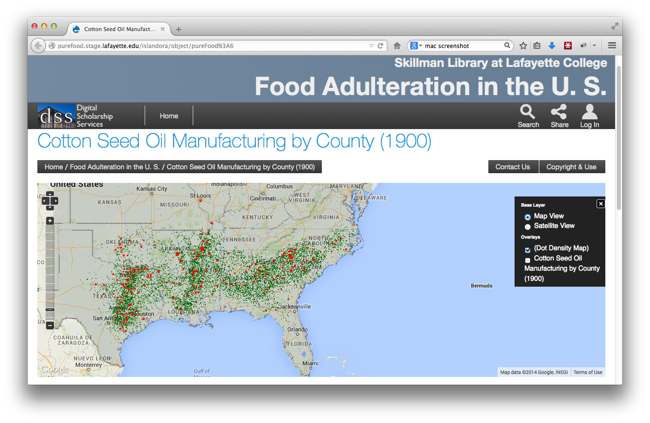
Prototype GIS mapping application for Benjamin Cohen’s Pure Food project.

The maps for this project were created in partnership with John Clark, DSS’ Data Visualization & GIS Librarian. Working with Professor Cohen and his EXCEL Student Matt Plishka ’15, Clark has transformed the data tables collected from historical sources into geospatial datasets, which can be ingested into our digital repository and displayed online in an interactive mapping interface.

This project marks a new digital landscape for DSS and showcases a new mapping platform that will eventually be made available to other Lafayette researchers as well. “Both Benjamin’s and Andrea’s projects extend the current repository to include geospatial information,” explains Eric Luhrs, director of DSS. “Now that this infrastructure is in place, we’ll be able to create similar mapped environments for future projects.”

Mapping and Memories: Easton’s Lebanese Neighborhood

In addition to utilizing this mapped environment, Andrea’s project also includes an element of crowdsourcing. Begun in 2007 as field work with her students, the project examines the demolition of Easton’s “Syrian Town” a once a thriving multi-ethnic community destroyed when over 800 homes were torn down under the auspices of urban renewal in the 1960s. Though the wounds of this destruction are still felt by many of the former residents, now in their 70s and 80s, there is no archive, no public display that marks its existence.

Smith has been working with her students to preserve the memory of this unique space through an oral history project that collects the residents’ photographs and stories. With help from Paul Miller, Digital Production Manager for DSS, Smith and her students held “Scan-a-thons” with local residents. The team scanned and collected hundreds of photos and memorabilia for residents helping them preserve their family memories and helping to build a digital collection.

DSS-screenshot-lebanesetown-VRE

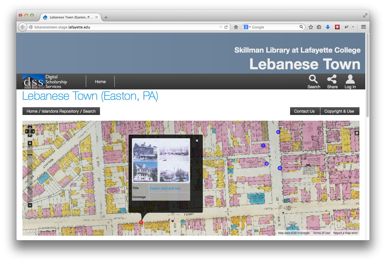
Prototype map-based crowdsourcing application for Andrea Smith’s Lebanese Town project.

With funding from the Mellon grant, she is able to share her findings even more broadly. The new application developed by DSS uses a base map made from Easton Area Public Library insurance maps dated 1919, when the Lebanese neighborhood still existed, to geo-reference the images and stories Smith has collected.  Smith and her team will then pin stories and images to the map virtually recreating the neighborhood and its culture. The next step of the project will include the functionality for residents to upload and share their own stories and photos adding to Andrea’s existing collection.

The Mellon Digital Humanities Steering Committee is now accepting applications for this year’s program. If you would like to submit a proposal please submit your application here.


For more information on starting a digital project with DSS or applying for an internship opportunity contact us at digital@lafayette.edu, or call (610) 330-5796.

“Collaborating Digitally:” Alena Principato ’15, DSS’ Eric Luhrs, and Professor Chris Phillips present the Easton Library Company Project at Bucknell

IMG_0837

Eric Luhrs, Chris Phillips, and Alena Principato at the Bucknell Digital Scholarship Conference

EXCEL student Alena Principato ’15 presented her work on the Easton Library Company Project alongside project creators Professor Chris Phillips of the English department and Eric Luhrs, Director of Skillman Library’s Digital Scholarship Services team, at the first annual Bucknell Digital Scholarship Conference this week.

The conference “Collaborating Digitally: Engaging Students in Faculty Research,” was sponsored by Bucknell University in Lewisburg, PA. It brought together a wide range of digital scholars focused on expanding digital projects into the classroom and into the research profiles of both graduate and undergraduate students.

Together the three presented on the panel “Old Records, New Questions, New Collaborations” where Alena was able to share her story as a contributor to the ELC, a project that includes digitizing and transcribing the lending records of the Easton Library Company from 1811-1862. These ledgers contain unique insights into the reading practices of 19th century readers as well as into the local Easton community of the era. From the students’ transcriptions, the DSS team has taken this data and transformed it into a relational database. Once complete, this project will allow users to investigate and visualize this data on their own and discover new relationships between readers, lenders, and the community.

Alena has been active with the project under Professor Phillips’ guidance since her arrival at Lafayette as a freshman. Now three years later, she is an expert on transcribing the records and has trained several other EXCEL students and worked directly with DSS to streamline the transcription process.

ELCcollage

Sample ledger facsimile, relational data table, and network graph visualization.

The panel also included the team’s colleagues Professor of Public History Kyle Roberts and undergrad Evan Thompson ’15 from Loyola University in Chicago. Their work on the Jesuit Libraries Provenance Project explores the history of Loyola’s original library  collection and parallels that of the ELC. Their presentation provided an additional model for integrating faculty scholarship into the undergraduate experience.

To foster student faculty collaborations like this one and to encourage the inclusion of digital methodologies into student research, the Digital Humanities Steering Committee has opened a call for proposals that includes funding for EXCEL students like Alena and for integrating DH methods in the classroom. For more information visit the steering committee’s website at sites.lafayette.edu/dhlaf.


For more information on starting a digital project with DSS or applying for an internship opportunity contact us at digital@lafayette.edu, or call (610) 330-5796.


John Clark and GIS at the Social Science History Association Conference

sshaJohn Clark, Data Visualization & GIS Librarian with Skillman Library’s Digital Scholarship Services department participated in the 39th Annual Meeting of the Social Science History Association in Toronto this week. Over the course of four days John participated in and chaired a number of sessions featuring cutting edge research projects in digital and spatial history.

The Association brings together a broad interdisciplinary group of historians and social scientists organized in a variety of thematic research networks. The Historical Geography network, for which he serves as a co-chair, features many of the earliest adopters in the use of Geographical Information Systems in historical research and for many years has been one of the principal venues for the presentation of innovative work creating new spatial histories and historical geographies through GIS research methods.

The presentations at this year’s conference reflected continued growth in these methodologies that now reach beyond desktop GIS tools to include the development of web-based virtual research environments (VRE) much like those under development at Skillman Library’s Digital Scholarship Services repository.

While at the conference John chaired two sessions. The first focused on progress made at the Collaborative in Historical Information and Analysis (CHIA) at the University of Pittsburgh’s World History Center where researchers are creating a world-historical data archive covering the past four centuries along with a data integration tool, Col*Fusion, aimed at harmonizing and normalizing datasets from a wide variety of knowledge domains.

The second, a roundtable titled Historical Atlases, Yesterday and Today featured a lively discussion of the genre while focusing on two recent publications; the Historical Atlas of Maine (University of Maine Press, 2015) and the digital republication (University of Richmond Digital Scholars Lab, 2013) of the classic Atlas of the Historical Geography of the United States (Carnegie Institution and American Geographical Society, 1932) featuring animations and other web-GIS functions applied to the original content.

The sessions will be of interest to both digital humanities scholars and social science researchers at Lafayette. To learn more about the latest in new research methods and projects using GIS contact John at clarkjh@lafayette.edu.


For more information on starting a digital project with DSS or applying for an internship opportunity contact us at digital@lafayette.edu, or call (610) 330-5796.