Professor Andrea Smith and DSS capture Easton history in community “scan-a-thon”

Easton residents joined students from Professor Andrea Smith’s Social Memory class to contribute to the ongoing digital public history project “Lebanese Town.” Together with DSS’s Visual Resources Curator Paul Miller, Smith and her students collected and scanned photographs, post cards, and memorabilia from the Easton community. The project aims to reconstruct Easton’s Lebanese neighborhood that was lost to urban renewal in the 1960s. The materials collected today will be added to the growing archive that seeks to preserve the memory of this eclectic, diverse neighborhood.

Scanathon2

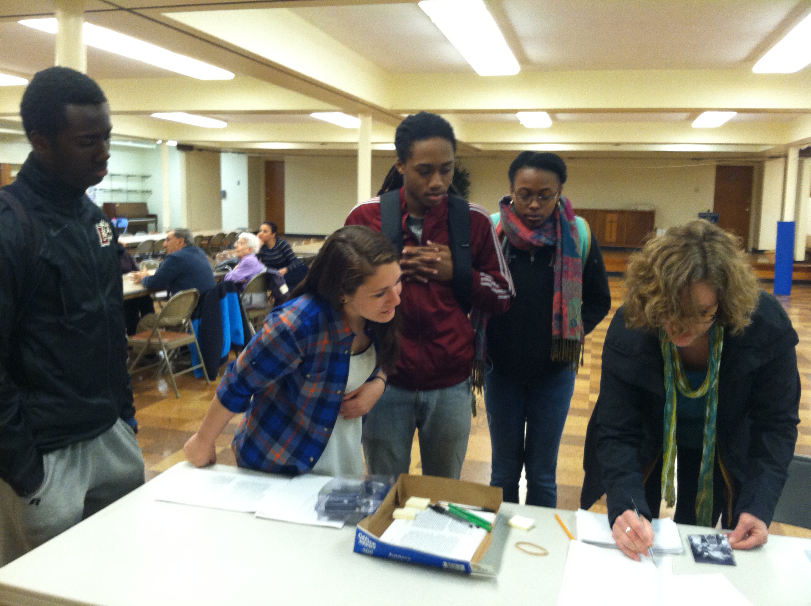
Professor Smith and students from her Social Memory class set up their materials.

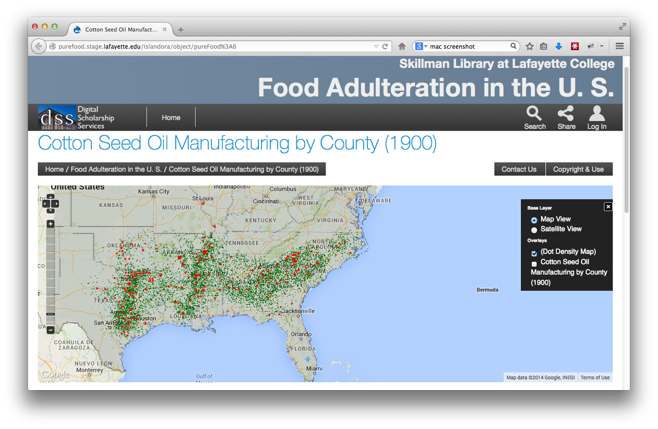
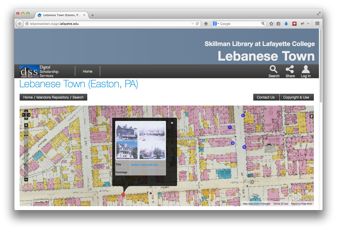
Professor Smith has been working on this project in her classes since 2008 and with her students she has compiled the stories into a book that the contributors help to edit and add to over time. The project has now grown into a digital project where these stories, images and photographs will be included on an interactive map. To learn more about the larger project see our previous post about our latest digital humanities projects.

This week’s event was the second “scan-a-thon” Professor Smith has held to help collect local materials. Over the years she has amassed a mailing list of residents who once lived in Lebanese Town who now often attend events not only to bring additional materials for the collection but to reminisce about their time together in the neighborhood.

Scanathon1

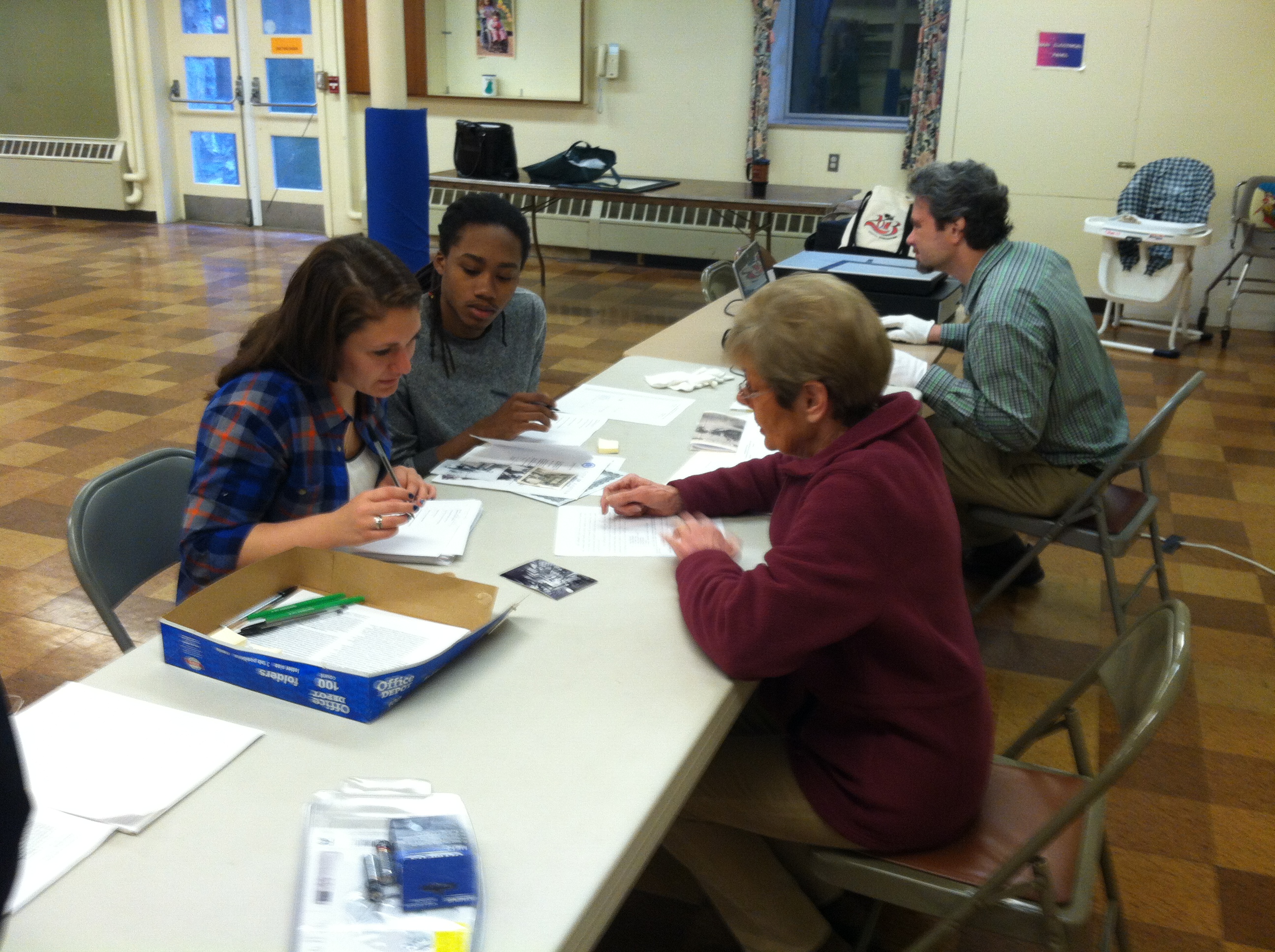
Students record a contributor’s story and catalog her photos for Paul Miller to digitize.

These meetings give the students a unique view into Easton’s past as they get to hear stories of the town as it was decades ago. The contributors tell them how amazing the bread was at Leone’s Bakery, and recount old world remedies like curing whooping cough with kerosene or a headache with potato slices. Moreover, they remember Lebanese Town fondly as a close-knit community of friends and neighbors. As the residents talk, the networks and fibers of the community begin to emerge. With so many stories already collected, this term’s students are able to start pulling these threads together writing chapters that focus on shared experiences that can now be told from multiple perspectives. The latest version of the book will be presented to the contributors at a special event at the Sigal Museum on May 7th.

As this growing archive is made digitally accessible, this local history will reach a new audience of both contemporary Easton residents and the Lafayette community of students. Once launched, users will be able to add their own items to the map creating a rich exhibit for the entire Easton community.


For more information on starting a digital project with DSS or applying for an internship opportunity contact us at digital@lafayette.edu, or call (610) 330-5796.


New Digital Humanities Projects at Lafayette

The Mellon Digital Humanities Steering Committee has issued a new call for digital humanities proposals in conjunction with Skillman Library and DSS. The proposal offers funding for those looking to incorporate digital scholarship in the classroom, as well as those looking to invest time in learning digital humanities methodologies and tools. For more information about this program visit the Mellon DH Steering Committee’s site or view the full call.

This call follows last year’s Summer Fellowship Program, the results of which are now under development with DSS including Anthropology Professor Andrea Smith’s “Mapping and Memories: Easton’s Lebanese Neighborhood,” and Engineering Studies Professor Benjamin Cohen’s “Pure Food Project.” Both of these projects serve as innovative examples of how digital tools can help in the discovery of new kinds of research questions.

Pure Food Project

Professor Cohen’s project uses a geographic information system (GIS) to examine and map food adulteration in the context of rapidly expanding food supply-chains, enabled by growing railroad and steamship networks in the late 19th century. The project’s mapping component focuses on two aspects of the growing spatial separation of consumers from their food supplies. The first charts the growth of the production of specific adulterants, for example cottonseed oil, which was mixed with olive oil and lard as a low cost substitute. Such production locations are displayed alongside concurrent maps of related themes, such as the continental growth of cotton production in the United States, and expanding global trade patterns. The second, still in development, will provide a geographic visualization of published information about food adulteration. This genre of literature ranged from sensational journalism to professional treatises informed by the growing scientific knowledge of chemistry and nutrition. The aim of this GIS application is to map both the publication of a selection of books on this subject, as well as to map the locations of adulteration incidents as reported from within these texts.

Prototype GIS mapping application for Benjamin Cohen’s Pure Food project.

The maps for this project were created in partnership with John Clark, DSS’ Data Visualization & GIS Librarian. Working with Professor Cohen and his EXCEL Student Matt Plishka ’15, Clark has transformed the data tables collected from historical sources into geospatial datasets, which can be ingested into our digital repository and displayed online in an interactive mapping interface.

This project marks a new digital landscape for DSS and showcases a new mapping platform that will eventually be made available to other Lafayette researchers as well. “Both Benjamin’s and Andrea’s projects extend the current repository to include geospatial information,” explains Eric Luhrs, director of DSS. “Now that this infrastructure is in place, we’ll be able to create similar mapped environments for future projects.”

Mapping and Memories: Easton’s Lebanese Neighborhood

In addition to utilizing this mapped environment, Andrea’s project also includes an element of crowdsourcing. Begun in 2007 as field work with her students, the project examines the demolition of Easton’s “Syrian Town” a once a thriving multi-ethnic community destroyed when over 800 homes were torn down under the auspices of urban renewal in the 1960s. Though the wounds of this destruction are still felt by many of the former residents, now in their 70s and 80s, there is no archive, no public display that marks its existence.

Smith has been working with her students to preserve the memory of this unique space through an oral history project that collects the residents’ photographs and stories. With help from Paul Miller, Digital Production Manager for DSS, Smith and her students held “Scan-a-thons” with local residents. The team scanned and collected hundreds of photos and memorabilia for residents helping them preserve their family memories and helping to build a digital collection.

DSS-screenshot-lebanesetown-VRE

Prototype map-based crowdsourcing application for Andrea Smith’s Lebanese Town project.

With funding from the Mellon grant, she is able to share her findings even more broadly. The new application developed by DSS uses a base map made from Easton Area Public Library insurance maps dated 1919, when the Lebanese neighborhood still existed, to geo-reference the images and stories Smith has collected.  Smith and her team will then pin stories and images to the map virtually recreating the neighborhood and its culture. The next step of the project will include the functionality for residents to upload and share their own stories and photos adding to Andrea’s existing collection.

The Mellon Digital Humanities Steering Committee is now accepting applications for this year’s program. If you would like to submit a proposal please submit your application here.


For more information on starting a digital project with DSS or applying for an internship opportunity contact us at digital@lafayette.edu, or call (610) 330-5796.