Author: zhangzh (Page 1 of 2)

Venetian Lagoon

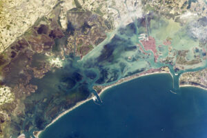
Recently, many news reported the flooding in the lagoon city of  Venice. The rising water level caused by flooding reached its highest peak in more than 50 years. While the flooding is the major concerning to many and is reported through media massively, I found the lagoon water system in Venice interests me more.

A lagoon is a shallow body of water separated from seas by islands. The Venetian Lagoon is surrounded by island barriers and the Adriatic Sea. Venice, the city, was built on islands situated inside the lagoon. I found that this would be a good topic for the story map. Firstly, the lagoon was built six to seven thousand years ago by engineers living in the Roman era, so there is a history approach connected to the waters. Besides, three canals run through that stretch of land, connecting commercial activities between Venice merchants and commercial vessels from other countries. This is the economic side. The interactions between the rising sea tides and rivers in the lagoon are interesting to delve into as well. What’s more, Venice’s water is highly polluted, because people dump sewage water in the canals. Therefore, this topic would also relate to the great stink that we discussed in the class.

Daldykan River in Russia and Bloods Resembles Each Other

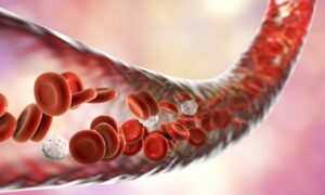
When reflecting on today’s class discussion, I recall that someone said there are rivers inside our bodies. I feel this in a same way. A blood vessel is similar to a riverbed that carries blood, which resembles a river itself.  Indeed, blood that mainly consists of hemoglobin in the human body delivers oxygen and nutrient to prevent our tissues and organs in different parts from dying. In this way, they also act as connectors.  Similarly, rivers connect different places and bring lives and vitality to areas they flow through.

Besides from that blood can be compared to rivers, I found a river that once had a blood color. The river on the right is called the Daldykan river in Russia. The red color was caused by overflowing of a chemical plant owned by a metal producing company called Norilsk Nickel. The river looks daunting at first glance but has an abnormal beauty. Now blood inside our body and rivers both resembles each other!

Cracks on the Bituminous Road Resembles Rivers

This crack line has so many properties that resemble a river. It only occupies a section of the bituminous road; it starts and ends at lines that separate the road to many blocks. Similarly, many rivers start and end at oceans or lakes that separate countries or states. The crack is formed by the infiltration of waters on the concrete. Likewise, rivers are mostly created by scouring torrents. Besides, waters in the crack permeate into areas around the crack, which really looks like flooding throughout a whole river after heavy rain.

Headwaters on Campus

Our campus sits on a hill. Every time it rains heavily, rainwaters will gather together to form a stream. From the center of the campus, the stream flows through the Sullivan Road, all the way down to the foot of the hill. The gathering surface water on our college hill reminds me of the way many rivers form. Mostly, the headwaters of rivers originate at marshy areas fed by mountain snow. In class, we discussed some rivers that begin their life as tiny streams running down a mountain slope. For example, the polluted holy river the Ganges starts as a little creek in the western Himalayas; the Yangtze River originates in Tanggula Mountain in the west of China.

A Tree on Campus that Looks Like Susquehanna River

On my way to the library, I found this tree with an abnormal shape that deviates it from its same kinds.  Unlike others, the trunk of this tree is so stumpy that you can barely see it, and the three vigorous branches form the main body of the tree. One of the branches crawls forward close to the ground, directing toward South College. The other two both grow upward, but each points toward different directions. 
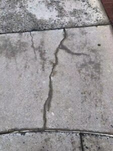
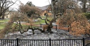
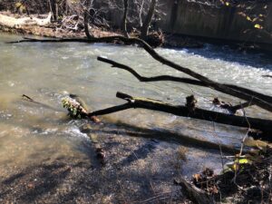
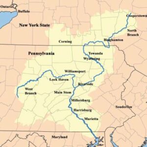
I think the shape of this tree resembles Susquehanna Rivers. The branch close to the ground is the main body of the river, and the two branches point toward the sky are respectively north branch and west branch of the river.

The Flexibility of Water In Bushkill Creek

Heading to the Bacon Festival in downtown Easton this morning, I intentionally past the Bushkill Creek, hoping to relieve pressure from school. The creek indeed looked vigorous, energetically flowing forward to a destiny of its own. This vitality of the stream transferred its energy to me, encouraging me to keep pursuing my personal goal. What is more, I found something different from this.  The flow of water in the creek is flexible – it had different speeds and forms at different places.

Beneath the Bushkill street, the water was rapid; along the Bushkill Drive, the water became so tranquil that it seemed to stop moving at the moment; approaching the dam near the Bushkill Curtain, the water began rushing and made me felt powerful. These different states of water reminded me of a quote from the “Analect of Confucious,” a collection of Confucian ideas in ancient China. “The wise find pleasure in water; the virtuous find pleasure in hills.” Wise men are as flexible as rivers – by the ability to see the nature of things, they could adapt themselves to changing circumstances without adhering sturdily to some fixed standard or rule.

Rivers in Maine and their History

While searching in the ArcGIS gallery to find some inspiration for the Story Map Project, I read the article about the history of Maine River that the librarian showed in class.  Humans in different periods in history react to the same river in different ways, but they all depend on the river. I found this means a lot. Many years ago before Europeans came to colonize this place,  native American settlers in Maine utilized everything in natural surroundings to canoeing on the river to survive.  Around the 19th century, the famous writer Thoreau wrote a book called “The Maine Woods” to narrate his three canoe trips in central Maine. Nowadays, canoeing on rivers in Maine becomes a recreational activity for people and provides business opportunities for organizations that offer trips.

Schuylkill River Trial in Philadelphia

During fall break, I went to Philadelphia. Southwest part of Schuylkill River, where it meets with the Delaware River, runs through the city. Known this, I spent some time walking on the Schuylkill River Trail at night. The trail near the river creates a recreation area for citizens that separates them from the hustle and bustle of ordinary life. Everyone has a way to enjoy what the river has offered. Wandering along with the trial, I saw some people running with the flow of the river; some lay on the grassy bank; others walked their dogs in a park next to the trial. A speeding train flew past by, only left a blurred outline in the picture above. However, the water stays tranquil no matter at what time in a day, bringing a sense of peace to people walking by.  It is harmonic that the natural river and human trace in the metropolis complement each other.

Cuyahoga River

Cuyahoga River, in Northeast Ohio, flows through the city of Cleveland and empties into Lake Erie. In the later 20th century, the river was one of the most polluted rivers in America.  Because of sewage and human waste dumped by Cleveland city, wastewater poured by unregulated industries, and stormwater with polluted materials flowing into it, no life could live in the river. What is more, the river was caught on fire more than 13 times. The picture above shows that, in 1969, sparks leaking from a passing train ignited pollutants and caused an intense fire.  The government realized the seriousness of the problem and enacted several Clean Water Act since then.  Thanks to many cleaning actions, the river now become an asset to Cleveland. Amazed by Cuyahoga’s transformation, I believe all of the efforts to protect the river nationwide are worthy.

Fisher Quad Bioretention Area

This small charming roundabout between Fisher Halls and Kamine Hall is modified by Lafayette students to control stormwater. Because our campus locates in the Bushkill Creek watershed, stormwater accumulating on the surface of campus combining with pollutants and sediments will run into Bushkill Creek. The creek will thus be polluted and damaged by stormwater. In 2017, students from our school built this area to alleviate this problem. They carefully chose soil and native plants to increase biodiversity and stormwater infiltration. There are five species of flowers in this area and they have different colors. Red, blue, yellow, orange, all these colors complement each other and constitute a vivid canvas. I found it is so ingenious that these flowers not only aesthetically complement each other but also have specific functions. For example, the Green and Gold flowers in the middle of the picture provide low-growing ground cover, while the orange flower in the back called Butterflies Milkweed attracts butterflies and bees.


« Older posts

© 2024 What is a River?

Theme by Anders NorenUp ↑