Author: zhangzh (Page 2 of 2)

Exploration along Bushkill Creek

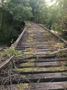
Yesterday afternoon, I had an adventure, or an exploration, along the Bushkill Creek. Started from the little dam down the hill of Lafayette College, I reached somewhere west side of Easton cemetery. For a while, as I walked along Bushkill drive and thought I lost the creek-I could only see the highway and could not find a way to access the creek again- an old wooden bridge suddenly came into my sight. I was so delighted by this discovery and decided to walk across the bridge. However, doing it was not easy because the bridge is mostly rotted. The gaps between the logs are very large, and the mosses make it very slippery to walk on. I was a little proud after walking across it successfully. When reached the other side of the river, I found a quite famous nature trail I didn’t know before. Walking along the trail back to school, I saw colorful fabrics that hang between tree branches, artistic display of pebble that form a circular labyrinth, and many graffiti-arts. Later, I knew from an exhibition board that the trial was named after Karl Stirner, a dedicated man who contribute tremendous artworks to Easton. It was a joyful exploration.

Sumida River in Tokyo

The river above is the Sumida River that flows 17 miles through Tokyo, Japan. It discharges into the Tokyo Bay and the Pacific Ocean. I took these photos during a vacation to Japan this summer. The cruise boat shown in picture 1 brings me from Asakusa to the Bay.

I thought that the boat would encounter torrent when close to Tokyo Bay. Out of my expectation, the water is placid and smooth throughout the entire journey. Comparing to highly polluted Ganges River, I was amazed by the peaceful interactions between densely populated central Tokyo and Sumida river. However, the river was actually deteriorated and contaminated until recently. In the 1950s and 1960s, due to rapid urban development, the river no longer became a habitat for aquatic and was called a “River of Death”.  Its biochemical oxygen demand reached 60 milligrams per liter in the late 1960s, meaning the pollutant were so many that aerobic organisms do not have enough oxygen to oxidize and break down them.

To make the river as clean as shown in the pictures, the government banned factories pouring effluent into the water, collected human waste, and built some new sewer systems.

Confluence of Jialing and Yangtze River

I took the picture above at city Chongqing in China, which is located on the upstream of Yangtze River and southwest of China. The bridge in the picture is heading  to a part of the city that resembles an island. It’s near the confluence of Yangtze river and  Jialing river, one of the largest tributaries of Yangtze River.  A little further east in the image is a wharf that separates two rivers in a shape of V.  On the river surface in front of the wharf,  one side is yellow and muddy Yangtze River water, the other side is jade-green Jialing River water. That obvious dividing line at the junction of water flow attracts many visitors.

At then,  I just felt it’s a miracle and did not do any research to understand why this happens.  Now I know this formation is partly because of a heavy rainfall in one upstream despite the dryness in that of the other.  In essence,  the color difference is caused by different water composition especially the distinct sediment and silt content in the two river. Thus, when the raining season come, these difference would highlight out.

Newer posts »

© 2024 What is a River?

Theme by Anders NorenUp ↑