
Floods on The Rhine
Living along the Rhine River, I have heard a lot about its history of flooding. The river itself is one of Europe’s most important transportation routes, yet its capacity for destruction is unmatched by any other weather phenomenon in the area.
Stretching over 1,230 kilometers all the way from Switzerland to the North Sea, the Rhine plays an essential role in tourism, commerce, and daily life. However, after a period of heavy rainfall, the river can transform into a dangerous flood risk for cities like Bonn, Cologne, and Koblenz. All three of these cities have had to make significant innovations in flood management to prevent the destruction of both property and human lives.
In History
The Rhine floods as a result of either prolonged rainfall or rapid snowmelt in the Alps, as well as saturated soil conditions that prevent absorption.
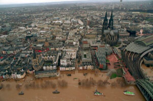
The worst recorded one of these floods in recent history occurred in 1993, when the Rhine reached a peak of 10.7 meters (35 feet) in Cologne. This forced thousands of people to evacuate and left tens of thousands homeless.
More recently, in January 2018, the water levels in Bonn exceeded 8 meters (26 feet). The water flooded over the riverbanks and significantly disrupted transportation in the city.
Management Strategies
Due to the risks to life and property, city planners and engineers have developed flood defenses that help to minimize the Rhine’s impact. In Bonn, for example, flood barriers and large embankments along the river serve as a first line of defense. The city also makes use of mobile flood protection walls and underground drainage tunnels to divert water away from critical infrastructure.

One of the larger scale projects currently underway is the Rhine Flood Retention Basin System. This system is comprised of multiple basins spread along the Rhine that work as overflow basins when the water level rises too much. They store excess water before gradually releasing it over time, which prevents major surges downstream.
The city of Cologne, just 20 miles north of Bonn, has taken its preventive measures a step further. A smart monitoring system makes use of sensors to track real-time water levels and predict floods before they happen. This allows for a quick response to early warnings, minimizing potential damage.
Furthermore, the city itself has adapted to the imminent threat of flood water. Shops feature flood-proof doors and use elevated storage areas. Parking garages near the river close at the first sign of rising water, public transportation routes adjust as necessary, and ferry services are usually suspended until conditions improve.
Signs of The Past
Although I have not seen the Rhine flood, I have noticed signs of how seriously the region takes flood preparedness. Located in downtown Cologne is the Pegel Köln, also known as the Cologne Gauge or simply ‘The Pegel.’
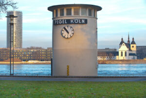
Although this device resembles a tiny clock tower, it is actually a real-time water level indicator that has been informing the community since 1891.
The water level is nothing to be concerned about currently, however, the full range of the indicator serves as a sobering reminder of how high the river can get.
The Future
Engineers and urban planners continue to develop methods to decrease the risks associated with the flooding Rhine. Future concepts include expanding natural floodplains, improving drainage networks, and investing in green infrastructure, such as permeable pavement and rain gardens that absorb excess water efficiently. This balance between human infrastructure and natural forces has been very interesting to learn about so far.
Written by Brendan G
References
German Federal Institute of Hydrology (BfG). (n.d.). Retrieved from https://www.bafg.de
City of Cologne. (n.d.). Flood monitoring system. Retrieved from https://www.stadt-koeln.de
Rhine Flood History Report. (n.d.). Retrieved from https://www.rheinfloods.eu
Explorial. (n.d.). Cologne Pegel Köln. Retrieved from https://explorial.com/sights/cologne-pegel-koln/