The Bushkill Creek watershed encompasses 80 square miles of Northampton County, PA, stretching from Blue Mountain to the Delaware River in Easton, PA (not to be confused with the other Bushkill Creek of neighboring Monroe County). Most of the creek is classified as a HQ-CWF stream for High Quality Cold Water Fishery. BSC is currently working to upgrade portions of Sobers Run in Bushkill Township to EV (exception value) status. Groundwater recharge along the wooded slopes of Blue Mountain provides a critical source of high quality baseflow to the headwaters of the Creek in Bushkill, Plainfield, and Moore townships. Wetlands along the foot of the mountain also help to buffer these headwater streams from storm runoff while providing important wildlife habitat. Most of the upper half of the basin is located in shale and slate geology, and is dominated by woodlands, agriculture, and low-density residential development. The wooded areas generally follow the streams (mainstem, Sobers Run, Engler Run, and Little Bushkill Creek), forming “greenways” from Blue Mountain to Jacobsburg State Park. These riparian corridors absorb rainfall and runoff, keep the streams shaded and cool, and provide important habitat for flora and fauna. It is critical that these areas are not over-developed. (Sourced from “The Bushkill Creek Watershed” Website – “Watershed Description” Page)
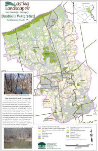
Map of the Bushkill Creek Watershed and Surrounding Areas within Northampton County. Sourced from heritageconservancy.org