MTA Subway Time App

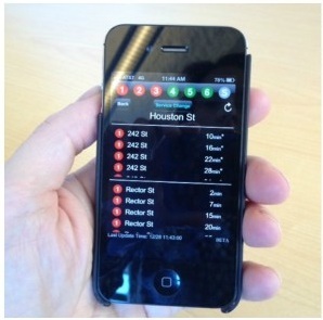
The Metropolitan Transportation Authority of New York City has unveiled a new Iphone App.  This App gives you real-time train arrival information for selected routes of the New York City subway system.  Knowing exactly when your train will arrive will reduce the time you spend waiting on the subway platform, and let you know of any service delays or reroutes before you pay a fare.  It was released on September 28, 2012.

There is one catch with the app though, it only operates for seven lines; the 1, 2, 3, 4, 5, 6, and the 42nd street shuttle.  The L Line will be added within year.  Nevertheless, that is only a fraction of the system making this app useless for most people.  NYC Transit President Tom Predergast said riders using the “lettered lines” will have to wait for their lines to be added to the app.  use signaling technology that “remains little changed since a time before computers, microprocessors, wireless telephones or handheld electronic devices.” He said the system works to prevent collisions “but it cannot offer us a digital feed.”

Who knows what day that will be when all train lines are included in this app?  It’s going to be a while because it’s all about the money.  However, it is nice to use for those seven lines right now.  I have used it and waited in a cafe until I had two minutes to catch the 5 train.

Source: http://transportationnation.org/2012/12/28/some-nyc-riders-can-now-use-phones-for-real-time-subway-arrival-times/

New Hudson River Crossing in New York City? Part III – Why No New Hudson River Crossing to Manhattan?

I have written a comprehensive report for my Sustainable Transportation course at Lafayette College that answers the question on why we have not built a new crossing linking Manhattan and New Jersey.  This was a project assigned to our class addressing transportation issues in the United States.  Being from New York City, I chose this topic because I wanted to know why I have to wait in traffic for up to an hour on the approaches to any of the existing crossings.  What I have discovered and written explains the social, political and economic attitudes that stagnated the highway growth in the New York Metro Area after the expansion of the George Washington Bridge.  It will also give insight on the future of crossing the Hudson River.  The PowerPoint associated with it will be posted soon.

New Hudson River Crossing in New York City? Part II

Many proposals in the last half decade have been dreamed and/or stopped dead in its tracks to construct a new Hudson River crossing connecting Manhattan and New Jersey.  One of them is the ARC Tunnel which was cancelled by New Jersey Governor Chris Christie in 2010 because of its spiraling out of control costs.  Subsequently, Mayor Bloomberg of New York City silently instructed municipal staff to begin studying the possibility of stretching the city’s subway system into the state across the Hudson River.

The 7 Train was the prime candidate in this proposal.  It would be extended about four miles westward to Secaucus Junction where a major hub for NJ Transit trains already exists.  With an estimated cost of $5.3 billion, this is almost half the cost of the cancelled ARC Tunnel proposal of $11 billion.  The explanation for this is that there are already existing tunnels that the 7 Line runs through in Manhattan that this new Hudson River tunnel would connect to; the ARC Tunnel did not have this advantage as major tunneling would have to be done underneath the streets of Manhattan.

The conception of this new plan is unique because it would be the first subway to go outside New York City’s borders.  It would connect New Jersians to Times Square, and Grand Central Terminal, both major train hubs.  This plan is brilliant because it costs half as much and would relieve congestion on existing Amtrak, NJ Transit and PATH trains.  It would provide more capacity and spur development of areas in Manhattan and New Jersey it runs through.

Extending the 7 Line across the Hudson River to New Jersey should be high priority for the two states.  It is widely known that we need to build additional crossings from Manhattan to New Jersey and when there is something available at a bargain compared to other proposals, we should take it.

Map of the Proposed 7 Train Extension

Source: http://www.thetransportpolitic.com/2010/11/17/to-replace-the-arc-tunnel-a-subway-extension-to-new-jersey/

Source: http://www.nytimes.com/2010/11/17/nyregion/17tunnel.html?_r=1&hp

New Laws On the Books for NYC’s Commercial Cyclists

New York City has many great restaurants and hot spots for people to get the best cuisine or get it delivered.  The next time you see a person on a bike delivering you food they must have completed a training course for safe cycling in the city.  This is an unprecedented move to regulate cyclists in the city who at most times do unsafe things such as running red lights, and going the wrong way on a street.

Starting in January, 2013, commercial delivery cyclists will have to where helmets, safety vests, and abide all moving and safety rules.   They would also have to carry an ID stating the business they work for.  The business they work for would fit the bill for any safety violation while the cyclist would fit the bill for any moving violation. New York City is cracking down on bicycle law breakers as it poses a safety risk to pedestrians, motorists and to the cyclists themselves.

The New York City Department of Transportation has hired six inspectors to inform local businesses of the new rules and to make sure they are prepared for them this coming January.


Source: http://transportationnation.org/2012/09/27/bike-inspectors-go-door-to-door-in-nyc-telling-delivery-cyclists-to-toe-the-line/

Source: http://transportationnation.org/2012/10/25/commercial-cyclist-legislation-now-law-in-new-york/

Is Suburban Sprawl Good or Bad? Part I

Suburban Sprawl

Throughout my Lafayette College career, I was accustomed with the idea that suburban sprawl is bad.  It requires a lot more land compared to a city, people have to travel farther to work contributing to longer drives, public transportation is inadequate at these areas and it is a very insipid place.  It also cements the car more in our society.  I even wrote a blog on this topic and described the problems with suburban sprawl.

So if these ideas were implanted in my mind for the last three or so years, how can it be good?  Well, in class this past Tuesday we had a very interesting guest by the name of Mr. Wendell Cox.  He explained that cities should naturally expand and grow to facilitate economic growth.  He went on to say that the only way to eradicate poverty and protect the environment is by achieving economic sustainability.  In other words, in order to have social and environmental sustainability is to first have economic sustainability.

According to Cox, there is a strong correlation between the amount of travel time between one’s job and home that facilitates maximum productive output by people.  I believe he said 45 minutes.  He was against building new expressways to urban centers to reduce travel times, but he stated that cities should expand with no restrictions so people can arrive to work sooner.  Well, how does that work?  Suburban areas are less dense than city centers so there is less congestion on area roads and expressways.  People arrive to work faster and production levels increase consequently achieving economic sustainability.

I am impressed because I feel that this is the first legitimate claim that states that we should endorse suburban sprawl.  I have been hearing the same opinions for years; that suburban sprawl was an egregious consequence of the interstate highway building era.  Mr. Cox gave some interesting points and I will try to get his PowerPoint he presented us and post it on my site.

Bayonne Bridge Reconstruction

The Bayonne Bridge

The Bayonne Bridge is the fourth-longest steel arch bridge in the world, and was the longest in the world at the time of its completion. It connects BayonneNew Jersey with Staten IslandNew York, spanning the Kill Van Kull which is a very active route for cargo ships to ports in New Jersey.  Its clearance is 151 ft, but that is no longer large enough for the new cargo ships that have increased there size and height to almost 200 ft.

In order to tackle this problem the Port Authority of New York & New Jersey (PANYNJ) has approved plans to raise the elevation of the bridge to 215 ft without tearing down the bridge.  It is a national Historic Civil Engineering Landmark, so the Port Authority did not have much of a choice.  It is quite fascinating in the video on how they would complete such an endeavor.

Not only will the bridge be raised to secure continued shipping operations, but additional benefits for the public would also be created.  The existing bridge has a 6 ft walkway, 10 ft wide travel lanes (two in each direction), with neither shoulders nor a median divider.  After the project is completed there will be 12 ft wide travel lanes, 6.5 ft right-hand shoulders, and a median divider for improved safety and to extend the life of the bridge.  Furthermore, a new toll gantry will be installed, allowing for quicker travel over the bridge and there will be a 12 ft wide bikeway/walkway for the entire length of the bridge with access ramps replacing existing stairs.

Source: http://www.panynj.gov/bayonnebridge/

Coordinated Traffic Signals

Green lights at consecutive intersections. The next red light in the distance will soon change green to permit vehicles to go.

Cities all over the world, no matter how different, have one problem that they have in common.  That is congestion.  A very easy and cost effective way to decrease congestion and keep traffic moving in the most efficient way is to coordinate signals.  This means that every signal as a motorist drives down a stretch of road will turn green depending on the amount of time it takes to reach the next signal or by the amount of congestion that is detected by the signal.

The time corresponds to whatever the speed limit is on the street which increases safety.  If a motorist drives faster than the speed limit he will hit a red light and stop.  This deters motorists from driving faster than the speed limit.  Manhattan has excellent examples of coordinated traffic signals on its one way north/south avenues.  You can go as much as two miles (roughly 40 streets) without stopping in the best conditions which is excellent for congested Manhattan.

However, I feel that this concept should be applied everywhere including outside of the the center city.  Why not Queens and Brooklyn or Northampton Street in Easton, PA?  I feel like this is a concept that is ideal for the motorist and the pedestrian.  One may argue that the traffic on these roads do not warrant coordinated signaling which is expensive.  However, if you look at an environmental standpoint, the amount of pollution that would be reduced is incredible.  If you look at an efficiency standpoint, people arrive at their destinations faster.  And when people arrive to their destinations faster, there are less vehicles on the streets contributing to a decrease in congestion.

Pittsburgh has implemented successfully a highly intelligent traffic signal system that is shortening commuter times while reducing emissions on congested city streets.  It resulted in a 40 percent reduction in vehicle wait time, 26 percent reduction in car travel time and a 21 percent cut in vehicle emissions.  That is awesome!  Why not do this in every city or on every major corridor?  Perhaps one day.

Source: http://www.popcitymedia.com/innovationnews/smartsignals09262012.aspx?utm_source=VerticalResponse&utm_medium=Email&utm_term=Finally%2C+a+traffic+light+that+reduces+po

Transportation State of Emergency

Flooded entrance of the Brooklyn Battery Tunnel

The New York governor declared an unprecedented transportation state of emergency forthe downstate New York City area.  This is a result of Hurricane Sandy flooding many automobile and train tunnels.  The hurricane caused a large portion of the NYC subway to close.  This resulted in a colossal amount of people driving to work causing massive gridlock in the center city which created a very dangerous situation.  The governor waived fees for rail, subways, and buses to encourage more people to take public transport.  The following link leads to a video describing the state of New York City and its transportation system.

http://video.msnbc.msn.com/nbc-news/49632950#49632950

Inflatable Plug in a test tunnel.

It is sad to see that New York’s transportation system is crippled by weather.  I understand that it was an unprecedented storm, but I feel that the system should be designed to withstand storms of this magnitude.  What ever happened to the flood gates or other alternatives that were supposed to be installed?  That could have stopped flooding in tunnels as the following link to an article suggests.  This article explains the use of a inflatable plug for tunnels and how could have prevented the disaster in New York City.

http://www.cnn.com/2012/10/31/us/new-york-subway-plugs/index.html

Redeveloping Communities Bisected by Expressways

A submerged section of the Brooklyn Queens Expressway in Brooklyn, New York.

In the 1950s, the construction of elevated and sunken highways marred many cities in the name of progress and the almighty automobile.  The Brooklyn Queens Expressway in New York City is a great example.  The picture on the right shows a portion of it in a trench and it is an eyesore that splits a neighborhood in half.  But what if we could bring the community back together by incorporating a design that would cover it and provide additional green spaces while also enhancing the bicycle and pedestrian environment?

Some options were unveiled by artists that really should be considered by the NYSDOT to bring a community back together.  Some of those options are shown below.  Cities across the country should incorporate these designs for redeveloping areas that were mauled during the construction of these expressways.

Artist rendition of creating a trellis Structure over the trenched rows which includes Photo-voltaic panels that generate revenue for the City. Photo-voltaic array could earn the city $USD312,500 per year through energy generation.

Artist rendition of maximum green. It creates a green streetscape with traffic calming, tree plantings, water sensitive design with the option for green screens/artistic fences.

Artist rendition of creating “green machine” bridges equipped with greenscreen or acoustic panels, PV, and decorative lighting, with the option of adding treatments from the ‘Maximum Green’ concept.

Source 1: http://buildipedia.com/in-studio/urban-planning/fix-the-ditch-enhancing-the-brooklyn-queens-expressway

Source 2: http://worldlandscapearchitect.com/starr-whitehouse-unveil-brooklyn-queens-expressway-options/#.UIh2Q51lR4d

Greenest Street in America Eats Smog

The Chicago Department of Transportation (CDOT) unveiled “the greenest street in America.” It’s the first phase of a two-mile stretch along Blue Island Avenue and Cermak Road on the city’s southwest side.  “This project demonstrates a full range of sustainable design techniques that improve the urban ecosystem, promote economic development, increase the safety and usability of streets for all users, and build healthy communities,” said CDOT Commissioner Gabe Klein. “It provides both mitigation and adaptation strategies by reducing its carbon footprint and integrating technologies that allow the infrastructure to address and adapt to climate change.”

Up to 80 percent of the typical average rainfall will be diverted through a combination of bioswales, rain gardens, permeable pavements and storm water features. More than 60 percent of the project’s construction waste was recycled and more than 23 percent of all new materials were sourced from recycled content.

By installing dark-sky friendly light fixtures, energy use of the street will be reduced by 42 percent. To help cut down on Chicago’s sweltering summer heat, nearly 40 percent of the public right of way was paved with light-colored, reflective material. Also, developers added a 131 percent increase in landscape and tree canopy cover.

The $14 million project was funded largely through Tax Increment Financing, along with $800,000 worth of grants from the Federal Highway Administration, Illinois Environmental Protection Agency and Midwest Generation.

This is a policy that should be implemented throughout every city, however it can easily become very expensive.  $14 million for a two-mile stretch of road, is a heck of a lot of money.  There needs to be more of a push from our federal and state government to help cities and other local municipalities fund such programs.  We cannot continue to keep cities the way they are.  It is unsustainable and initiatives such as this is the right path for a sustainable future.

Source: http://news.discovery.com/autos/chicago-constructing-greenest-street-121016.html          http://specials.news.msn.com/americas-greenest-street-eats-smog