Redeveloping Communities Bisected by Expressways

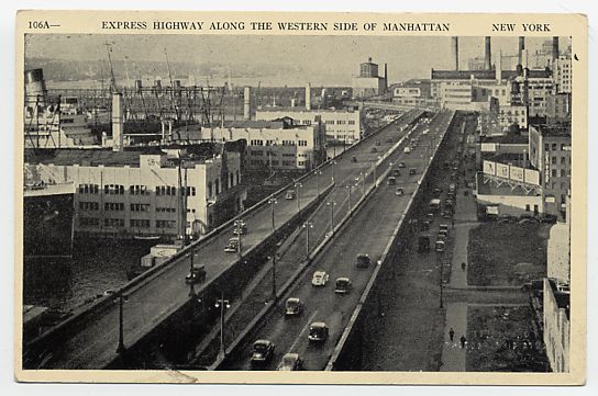
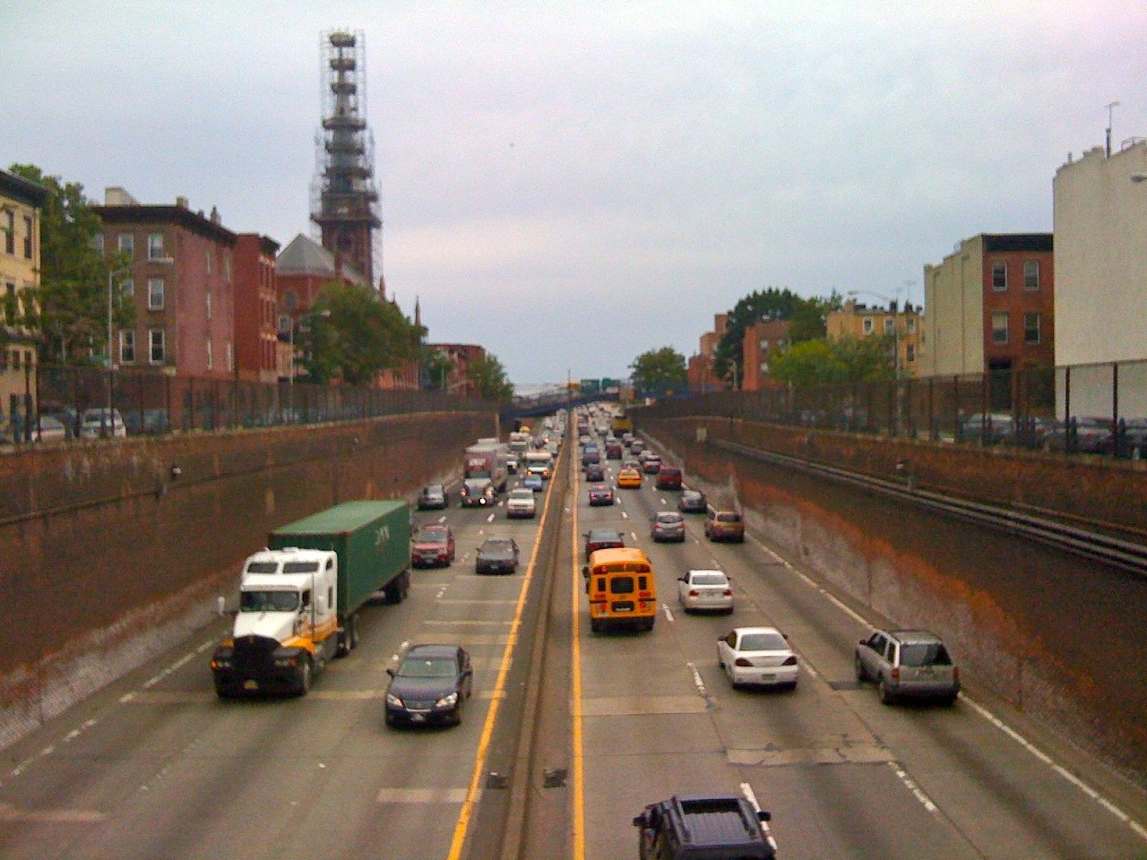
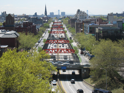
A submerged section of the Brooklyn Queens Expressway in Brooklyn, New York.

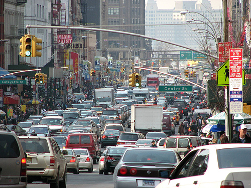
In the 1950s, the construction of elevated and sunken highways marred many cities in the name of progress and the almighty automobile.  The Brooklyn Queens Expressway in New York City is a great example.  The picture on the right shows a portion of it in a trench and it is an eyesore that splits a neighborhood in half.  But what if we could bring the community back together by incorporating a design that would cover it and provide additional green spaces while also enhancing the bicycle and pedestrian environment?

Some options were unveiled by artists that really should be considered by the NYSDOT to bring a community back together.  Some of those options are shown below.  Cities across the country should incorporate these designs for redeveloping areas that were mauled during the construction of these expressways.

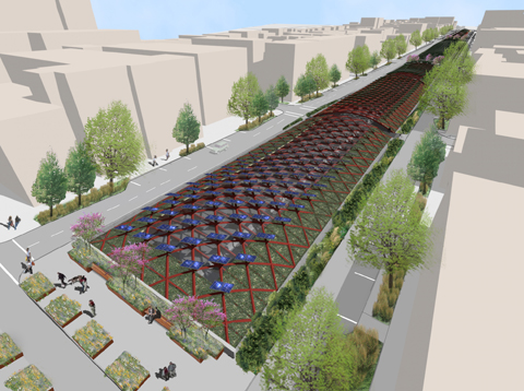
Artist rendition of creating a trellis Structure over the trenched rows which includes Photo-voltaic panels that generate revenue for the City. Photo-voltaic array could earn the city $USD312,500 per year through energy generation.

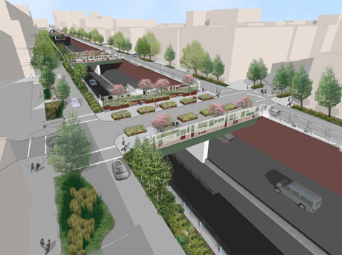
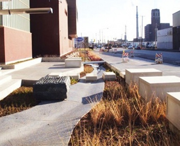
Artist rendition of maximum green. It creates a green streetscape with traffic calming, tree plantings, water sensitive design with the option for green screens/artistic fences.

Artist rendition of creating “green machine” bridges equipped with greenscreen or acoustic panels, PV, and decorative lighting, with the option of adding treatments from the ‘Maximum Green’ concept.

Source 1: http://buildipedia.com/in-studio/urban-planning/fix-the-ditch-enhancing-the-brooklyn-queens-expressway

Source 2: http://worldlandscapearchitect.com/starr-whitehouse-unveil-brooklyn-queens-expressway-options/#.UIh2Q51lR4d

Greenest Street in America Eats Smog

The Chicago Department of Transportation (CDOT) unveiled “the greenest street in America.” It’s the first phase of a two-mile stretch along Blue Island Avenue and Cermak Road on the city’s southwest side.  “This project demonstrates a full range of sustainable design techniques that improve the urban ecosystem, promote economic development, increase the safety and usability of streets for all users, and build healthy communities,” said CDOT Commissioner Gabe Klein. “It provides both mitigation and adaptation strategies by reducing its carbon footprint and integrating technologies that allow the infrastructure to address and adapt to climate change.”

Up to 80 percent of the typical average rainfall will be diverted through a combination of bioswales, rain gardens, permeable pavements and storm water features. More than 60 percent of the project’s construction waste was recycled and more than 23 percent of all new materials were sourced from recycled content.

By installing dark-sky friendly light fixtures, energy use of the street will be reduced by 42 percent. To help cut down on Chicago’s sweltering summer heat, nearly 40 percent of the public right of way was paved with light-colored, reflective material. Also, developers added a 131 percent increase in landscape and tree canopy cover.

The $14 million project was funded largely through Tax Increment Financing, along with $800,000 worth of grants from the Federal Highway Administration, Illinois Environmental Protection Agency and Midwest Generation.

This is a policy that should be implemented throughout every city, however it can easily become very expensive.  $14 million for a two-mile stretch of road, is a heck of a lot of money.  There needs to be more of a push from our federal and state government to help cities and other local municipalities fund such programs.  We cannot continue to keep cities the way they are.  It is unsustainable and initiatives such as this is the right path for a sustainable future.

Source: http://news.discovery.com/autos/chicago-constructing-greenest-street-121016.html          http://specials.news.msn.com/americas-greenest-street-eats-smog

HOT Lanes in Northern Virginia

The Virginia Department of Transportation (VDOT) has introduced HOT Lanes or High Occupancy Toll Lanes on the I-495 Capital Beltway corridor just south of Washington D.C.  Motorists who are willing to pay a fee would be able to drive in these lanes.  This would only occur if there is traffic in the regular lanes otherwise it would defeat the purpose of them.  The toll rates will vary depending on the hour and level of congestion.  If congestion is high on the regular lanes, the toll would be higher and vice versa.  Vehicles with three or more people can drive for free in these lanes no matter the time or level of congestion.

EZ Pass Flex Transponder

These HOT/HOV lanes will collect tolls using high speed toll collection methods where motorists would not have to stop to pay.  You must have an EZ-Pass transponder if you are going to pay.  However, this is not your typical transponder.  The picture on the right shows an EZ-Pass Flex transponder that must be used for these lanes where you would flick a switch between HOV status where you would pay nothing, and regular status if you have less than three persons in your vehicle and pay a toll.

This is an interesting concept that VDOT is implementing.  VDOT is widening their road by making drivers pay a toll for it.  This is actually indirectly creating a socio-economic gap where people who can afford and willing to pay can only take it.  Secondly, I believe it is based on the honor system because I could not find any information on what is stopping persons from simply switching to HOV mode when they have less than three people in the vehicle.  I feel that is a very large loophole in the system.  However, this system does encourage car pooling significantly which would reduce congestion.

Should we have a system like this across the country where congestion is prevalent.  Should motorists pay that extra fee?  Is it worth cementing car use more in our society to widen roads and encourage car pooling or should we just leave the roads the way they are?  Should VDOT have built bus dedicated lanes only or something else?

(https://www.495expresslanes.com)

Congestion Pricing

Congestion Pricing is a very contentious issue in the United States.  Mayor Michael Bloomberg of New York City tried to establish rates for motorists to enter the central business district.  This plan would have decreased traffic congestion, improve quality of lives and make NYC a healthier place, but there was not enough public support to push it through the New York State Assembly.

However, there are many cities around the world that have successfully implemented congestion pricing and has created a better city as a result.  London for example now has it and the revenues that are collected by motorists go directly into public transportation such as trains, buses and bicycling facilities.

There are obvious benefits to congestion pricing like boosting funding for a very limited transportation budget, but how can we change the preconceived notions of people who have been brainwashed to think that the car is the only way to go.  How can we change the preconceived notions of people that think public transit is inconvenient and crowded.  Perhaps if congestion pricing is implemented in cities, the latter question would no longer be a problem.

It is a tough sell to the people, but I believe if it was established in cities in the US, it would decrease congestion, make public transit better and increase the quality of life.  The cost of driving a private vehicle is incredibly cheap, and I believe people should pay for not just the costs at the pump, but a societal cost because it is so detrimental to our environment.


Cutting Off of Waterfronts

There are many limited access highways across the country that cut of the water fronts in cities.  Most of these highways were built along waterfronts because it was cheaper.  There were not as many building to demolish or overpasses to create.  The thought process of highway planners during the United States highway boom was to build the most cost-efficient highway.  As a result, society is now paying for its devastating impacts.

When you lose a waterfront, you lose vitality.  People are less inclined to go to these areas if access to it is difficult.  When you have a highway that separates the land from the water, it makes it more difficult for people get to it.  And when you don’t have an influx of people in areas, the area decays and becomes run down.  This is what happened to many cities across the nation.

There are solutions to such problems that some cities have done to beautify and encourage people to go to waterfronts that have previously been cut off by highways.  Some cities have buried the highway completely granting full access to the water.  Others, have removed the highway and created grand boulevards lined with trees and shrubs with many stop lights for pedestrians to walk over.   And there are cities that have reinvigorated areas by taking in to account the landscape the highway goes through and building many bridges across.

The most expensive solution is burying the highway and the cheapest is to create a boulevard.  Cities should think about how to revitalize these areas that are cut off by enacting these solutions.  New York City did it on its west side and will benefit many generations in the future.  Look at my blog post about the West Side Highway.  It goes into a little more detail.


The West Side Highway

The West Side Highway Viaduct before it was demolished in 1989.

The current West Side highway is shown in the header image on the top of this page.  It is now a grand boulevard lined with trees and bikeways making it one of the most aesthetically pleasing streets in New York City.  Of course, by its name it lies on the west side of Manhattan and is a major thoroughfare on that side of town.

However, the West Side Highway was not always like that.  It was once a limited access viaduct that stretched from the World Trade Center to the Bronx.  New York City on the west side was primarily an industrial area and having the viaduct proved valuable for business and commuters.  It was an expressway that bypassed all the congestion of New York City traffic and was praised for just that.

During the late 60s and 70s maintenance on the viaduct was considerably lacking.  New York City as like many other cities was going through rough economic times and could not afford the upkeep of its highways.  It came to a point that the west side viaduct was so structurally deficient that a cement truck on its way to fix the road deck collapsed a section of the structure in 1973.  How ironic.

The elevated highway was immediately shutdown.  Instead of fixing the problem, NYCDOT   did not want to invest the $88 million to repair it.  The structure remained standing for sixteen years before it was finally demolished in 1989.  However, there were plans in 1977 for the structure to be rebuilt, but drivers found other routes to get to where they need to go.  City officials did not find the economic and societal costs worth it.  Officials instead made it into a grand boulevard in 1999 which made the area much nicer.

The new open area on the water front has revitalized the west side of NYC and has benefited generations of citizens.  There used to be an rusting and decaying structure that was the blight of the west side and people did anything to avoid it.  Now people, want to live there and walk along the waterfront.  Old factory buildings were restored to offer living spaces.  The removal of the west side highway has benefited NYC in so many ways and I believe other cities in this country should take this as a good example and apply it to highways that cut off their waterfront.

(http://www.nycroads.com/roads/west-side/)

Interstate 78 in NYC

When the United States was going through the highway boom in the 50s and 60s, there were a lot of planned routes through every major city.  Most came to fruition, but many were not constructed due to community opposition or lack of funding.  Interstate 78 in NYC is one of those unbuilt routes.  It currently ends in New Jersey at the Holland Tunnel entrance, but there were plans for it to go through the tunnel, through Manhattan via the Lower Manhattan Expressway (unbuilt), over the Williamsburg Bridge to Brooklyn, via the Bushwich Expressway (Unbuilt) to Kennedy Airport, then north to the Bronx. The map above shows part of the route.

I actually think about, how NYC would be different if all the routes that were planned were actually built.  It would have been a very different place.  These additional routes would have eased congestion on the road network, but destroy many communities.  Furthermore, if you build new roads it creates an induced demand where more people than before would drive.  So these new roads would have eventually become congested anyway.

Canal Street is the arterial street in Manhattan that drivers take to drive between the Holland Tunnel and the Williamsburg & Manhattan Bridges. These drivers exited highways in New Jersey and Brooklyn and have no choice, but drive on local streets.

But is it better to have congestion on the highways and not on local streets?  I think so.  This is how it is now in NYC.  I-78 would have traveled in lower Manhattan connecting the Williamsburg Bridge to the Holland Tunnel.  That is a major corridor for drivers to travel between Long Island and New Jersey, but there is no highway link between them.  Currently, vehicles crowd the street, sometimes taking over an hour to travel one mile.  I cannot imagine that being good for air quality.

The original plans for the I-78 Lower Manhattan Expressway called for an elevated highway for the majority of its route which would require a lot of condemning of homes.  That is one of the major reasons to why it was not constructed.  It would have been an eyesore like some of NYC’s current elevated highways.

So today NYC is plagued with crippling congestion in its downtown area.  I think the only feasible solution that people would support is a underground expressway connecting the bridge and the tunnel.  I can see that happening one day because we are delaying a problem that continues to get worse. It would be extraordinarily difficult, but I find it cool to just picture such an achievement and driving through it.

The unbuilt Lower Manhattan Expressway

(http://www.nycroads.com/roads/bushwick/)

(http://www.nycroads.com/roads/clearview/)

(http://www.nycroads.com/roads/lower-manhattan/)