This is a picture of what the Buffalo Bayou in Houston looked like before and after Hurricane Harvey. This event greatly changed almost everybody’s lives in the greater Houston area. The Bayou is supposed to be able to obtain 32 inches of rain. However, it nearly rose to 53 inches and flooded everything near it. I live 5 minuets away from here and almost got flooded. I was very fortunate enough to be able to keep my house dry and we were able to come out the event safe!
Page 13 of 15
Here are a couple of pictures of the reservoir near me called the Boonton Reservoir. The reservoir’s main purpose is to supply Jersey City water. It is also the first location to implement continuous water chlorination back in 1908. Water chlorination is used to kill certain bacteria in tap water to protect people from contracting deadly diseases like cholera and dysentery. The picture on the right is a shot of the dam on the reservoir and I always drive by it and thought it was pretty neat.
This photo was taken in Washington State, in the Cascade range. The mountain you are looking at is called Mt. Baker, and it is actually a volcano. This picture was taken in mid-July while on a hike around the lake. While I couldn’t manage to find a photo of one of the rivers in the area, Mt. Baker is a glacier, and produces large amounts of runoff. It stands at almost 11,000 feet, and the elevation in this picture was around 3,000 feet, so the elevation gain from the lake to the top is massive.
While it may look nice, the Mamaroneck River serves as a hazard for thousands of golfers. This image was captured at my local golf course, Maple Moor. The river cuts straight across a few holes, and has swallowed up countless golf balls of mine. The challenge of hitting over a river can be quite entertaining, but there’s certainly an unintentional environmental impact. Not everyone can be expected to master the game of golf and completely avoid the water (especially not at a public course), so perhaps more work should be done to make golf balls biodegradable.
A picture from our kayaking trip (Taken with my GoPro). On this part of the river the water’s surface is flat and seems still but is moving quite quickly. The best part about the photo is that there are, other than our kayaks, no signs of civilization or human interaction with the river or surrounding land. It is a true nature experience.

DCIM101GOPROG0312343.JPG
Over the weekend I went to the Bushkill Bug Symposium and I found it very interesting. As I said before in class I met some fly fishermen and they described what its like flyfishing on the Bushkill. They told me how complex this way of fishing was, everything needed to be right to catch the fish. Things like what the Ph of the water, what type of bugs are underwater what bugs are on top of the water, that the temp of the water is, what time of day it plays an effect on what type of fish will bite the fly.
Though a bit redundant, I wanted to share this photo of the Bushkill Creek – a bit further down than where we were. I went down there when I was feeling stressed, and I found it incredibly peaceful and as small escape from the pressures of my classes and other aspects of college life. I stepped into the water again which was also nice, and walked own along the banks further down and came across a bridge (the small blue mark in the background). Where I was the water was a bit calmer, but there still was the sound of water further down the stream. A really nice spot.
While doing research on rivers online, I read an article about how tributaries of the Lackawanna and Susquehanna Rivers have both been damaged by acid from abandoned mine projects. Holes dug in the tributaries create water up flow that stains the water and rocks touching it. I thought this was an interesting subject and I didn’t know that this problem was so big in Pennsylvania.
This is a camelback bridge along the canal in Upper Black Eddy, PA. On Saturday, 9/7, the tour guide for the river trip mentioned that there are 6 of these bridges along the canal. The other 5 have been repaired, but this one has yet to be started. It can be walked across, but a vehicle would probably fall through. The bridge was originally built so that the farmer who owned the land on both sides could still access his land when the canal was built. These bridges are a historical landmark and beautiful feature of our area.
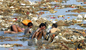
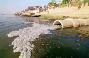
After reading about the Ganges, I was interested to learn more about the extent of the pollution that is present on the river. The interesting thing is that the pollution is coming from primarily two main sources: industry and religion, two fields that are usually never connected. Industries and factories located along the river drain toxic chemicals and untreated waste into the river, raising the level of toxins in the river and making it discolored. Pilgrims and other religious people who travel to the Ganges, the most important river in Hinduism, often leave mementos or objects in the Ganges, wanting to leave some part of themselves at the holy river, but this instead just further pollutes the river. It is also a very common practice in Hinduism for bodies or cremated remains to be dumped in the Ganges, to help the soul reach the afterlife, but this also pollutes the river and introduces bacteria into the river. Although this river is dangerous, due to its important religious significance, people refuse to stop bathing, drinking, or otherwise interacting with the river.