Author: Timothy Baier

Many Branches Resemble River

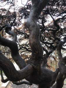
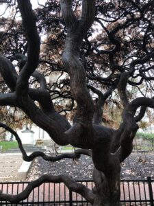
My second favorite tree on campus, a Japanese Maple, resembles the branches of a river and its tributaries. The outermost branches are small and join together into bigger branches that eventually meet at the trunk. The tree looks especially good when wet, bringing out the dark colors and contrasting lines along the branches that also resembles a stream.

Path of Least Resistance

In front of South College, I saw a man-made path across the grass connecting the road and another sidewalk. This path was created because students used the shortest path possible to get from one point to another. Rivers follow their windy path that has been created over time by eroding rock and sediment,  but every so often, the river will cut a new path that travels straight through a section of land instead of winding. It is as if the water is desperate to reach the ocean and decides to travel straight there, just as the students did.

Dam on the Bushkill

A night photo of one of the dams Lafayette owns on the Bushkill Creek. This is the dam we looked at during class that Lafayette plans to remove. The crumbling wall that I was standing on did not feel at all safe and the slope to approach it was slippery. The plunge pool was also noticeable because as the water cascaded over the falls, the water travelled in all directions and would  definitely be dangerous to be in.

Lafayette’s New River

A rainy day brought to my attention a river on the Lafayette campus. With the heavy rains this past week all of the roads on campus became a river of rainwater and leaves. The river followed the natural slope of the hill, flowing down in the direction of Easton. Like the Delaware, the road-river picked up objects along the way and they got caught in corners around the outside of the bend.

Delaware River Kayaking Trip

A picture from our kayaking trip (Taken with my GoPro). On this part of the river the water’s surface is flat and seems still but is moving quite quickly. The best part about the photo is that there are, other than our kayaks,  no signs of civilization or human interaction with the river or surrounding land. It is a true nature experience.

DCIM101GOPROG0312343.JPG

Delaware Water Gap/Mount Minsi

I took these photos while hiking Mount Tammany in Knowlton New Jersey. Pictured is the Delaware River as it runs through the Delaware Water Gap, dividing Pennsylvania and New Jersey. The mountain in the picture is Mount Minsi, the mountain we will be hiking later in the semester. The River has been running through the area for millions of years, cutting a hole through the mountain range slowly over time. Interstate 80 can also be seen following along the River, eventually crossing from NJ to PA.

© 2024 What is a River?

Theme by Anders NorenUp ↑