Day: September 13, 2019

Mount Baker Lake


This photo was taken in Washington State, in the Cascade range. The mountain you are looking at is called Mt. Baker, and it is actually a volcano.  This picture was taken in mid-July while on a hike around the lake. While I couldn’t manage to find a photo of one of the rivers in the area, Mt. Baker is a glacier, and produces large amounts of runoff. It stands at almost 11,000 feet, and the elevation in this picture was around 3,000 feet, so the elevation gain from the lake to the top is massive.
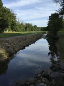
Mamaroneck River

While it may look nice, the Mamaroneck River serves as a hazard for thousands of golfers.  This image was captured at my local golf course, Maple Moor.  The river cuts straight across a few holes, and has swallowed up countless golf balls of mine.  The challenge of hitting over a river can be quite entertaining, but there’s certainly an unintentional environmental impact.  Not everyone can be expected to master the game of golf and completely avoid the water (especially not at a public course), so perhaps more work should be done to make golf balls biodegradable.

© 2024 What is a River?

Theme by Anders NorenUp ↑