Raging Rhine
During our first weekend in Germany, me and a few of my classmates decided to go to the city of Koblenz, a smaller city just down the Rhine from Bonn. Throughout our first week in Bonn, it had been rainy and snowy outside which caused the water level of the Rhine to rise. For what did not feel like incredibly heavy rains, the water rose up high enough to flood different parts of the city and it made me wonder what infrastructure did Koblenz and other river cities have to control such dynamic water levels. From the dry walkways we walked on we could see areas that had signs and bike racks sticking out of the water where a park once was and at first look these areas look like the floods were left unchecked, however this is more likely intentional.
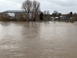
The international commission for the protection of the Rhine’s flood risk management plan’s primary tool for protection against flooding is the conservation of floodplains, a region of land that under normal weather conditions is frequently subject to flooding, like the small park we saw flooded in Koblenz. By allowing floodplains to remain undeveloped, the Rhine’s water level can be more easily controlled, relieving the need for the excessive use of retaining walls. And as these floodplains are used as parks, the times in which they are dry they are still contributing to the city as a whole.
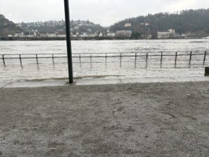
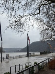
The water level indicator in Koblenz that day read 11 meters, which is the highest number the indicator can read, and yet the water retaining walls still preserved the city itself from flooding. The use of multiple water control systems, as well as having organizations that facilitate collaboration across the entirety of the river basin, allows for the water management tools deployed in each city to work in conjunction with each other, as opposed to working against each other.
-Andy
https://www.iksr.org/fileadmin/user_upload/DKDM/Dokumente/BWP-HWRMP/EN/bwp_En_2d_IFRMP_2021.pdf
Wowzers!! This is crazy, I can’t believe that they have floods in Germany. Did you get swept away in the “Raging Rhine”?? I hope you’re having a good time abroad.
Godspeed
-Owen B.
Thank you for the comment!
Godspeed
-Andy K.