Page 8 of 15

Tree bark river

I was walking on campus last week after class and noticed that the bark on this tree near Skillman Library has lines and cracks in it that resembles a river with many connecting streams and tributaries.


Merrimack River

Below is an image of the Merrimack River located in the Northeast of the United States. It spans 117 miles through New Hampshire, Massachusetts, and Maine. Currently it is on the list of America’s top 10 most threatened rivers. Waste flows through the river and contaminates it and goes off it the nearest brook or stream.

Rain River

Heading down to Fisher Stadium, I noticed these crevices within the wood chips on the curb. I realized that the heavy flow of water downhill from the rain that poured earlier caused these to form. The flowing water was strong enough to make its own pathway within the wood chips, just how rivers create their own pathways on Earth’s landscape.

Low Water Levels

While driving home for fall break, I noticed that the Delaware River water level was significantly lower than when we went on our paddle trip. The image above is the main river 5 minutes away from my house, and I was surprised by how low the water level is in this river was as well. You can see where the water normally is.  The lack of rain over the past couple months is showing across all bodies of water in the area.

Historic Delaware Canal

These two maps are of the Delaware canal that begins in Easton. For Tim’s and my StoryMap project we are researching the canal. I thought it would be great to show some of our progress and what you can do with the canal. The map on the left is a historic map with the locations of all of the locks. This is the path the coal carrying, mule pulled, boats would take to get to Easton. The map on the right is an updated map with all of the towns that the canal passes through on both sides of the river. It’s an amazing trip to take with plenty of good restaurants along the way if you have a bike and some free time.

Irrigation Drying Up Rivers

https://www.npr.org/sections/thesalt/2019/10/02/766510790/irrigation-for-farming-could-leave-many-of-the-worlds-streams-and-rivers-dry

I found an NPR article about how irrigation for farming could lead to many rivers being dried up. For example, many streams in Colorado and Kansas were no longer “functioning”, as in they were all dried up and the only thing there was a dirt path. These waterways get their water partially front groundwater, but farmers have been interfering through irrigation. The deep wells that have been drilled in already pretty dry areas, so when crops are grown there, the land becomes drier. Since it doesn’t rain a lot there, the plants grow by pulling water up through the ground. Farmers also pump water, so much so that the water table as fallen drastically. This has made it so the water cannot flow into the rivers anymore. The article mentions this happening in many other places too, such as California, India, and China. I think this is one example of the relationship between us and rivers. In this case, how our actions affect rivers and how changes in the river can affect us too.

Small plane crash lands in Susquehanna River

Last Friday, a man from Florida was flying his private plane and ran out of fuel. He had to crash land in the river, leaving the plane there. The small plane is still in the river. Hopefully it will be taken out of the river soon or the fuel and other chemicals from the plane might do damage to the water.

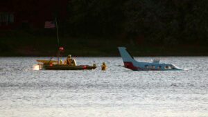
https://www.google.com/amp/s/www.abc27.com/news/local/harrisburg/plane-remains-stuck-in-susquehanna-river-days-after-crash-landing/amp/ Continue reading

San Pedro River and Ground Water Extraction

https://www.nationalgeographic.com/science/2019/10/groundwater-pumping-killing-rivers-streams/

Interesting article regarding the sustainability and health of rivers across the world. The article mentions how issues of unregulated, excessive water removal from under ground aquifers affects rivers such as the Ganges. Its startling, how research predicts that by 2050, between 40 and 70% of all rivers would have reached an ecological threshold that we may not come back from. The biggest issue with excessive groundwater removal is that in cases like the San Pedro River in Arizona, much of the water’s volume actually comes from aquifer resources, which are then replenished by rain, runoff, etc. Thus, the more we pump out, the less water is available to sustain the rivers flow, and if the water levels drop enough, habitats and marine life are in serious danger. This article I think is somewhat fitting, given that we had the presentation for the DRBC and have had discussions regarding river health.

Bushkill Curtain water levels

When I went downtown to watch a performance of Vanity Fair last weekend, I thought the river seemed lower than usual when I passed by the curtain. The water was at least a foot below the bottom buoy, and many of the larger rocks on the bottom of the riverbed were exposed and visible.  According to the National Weather Service, this region has received slightly more than average rainfall for the year-to-date, but over the last 2 months, it has received less rainfall than usual, anywhere from .5 to 1 inch less than usual. This may have contributed to the river seeming lower than it usually is.

« Older posts Newer posts »

© 2025 What is a River?

Theme by Anders NorenUp ↑