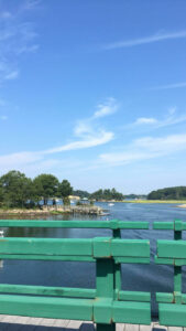
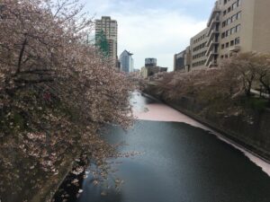
The river above is found in Tokyo, Japan, running straight through the city. I took this image while visiting Japan in 2017. It is one of many rivers that run through Tokyo, and is well maintained, with its banks being extensively landscaped as to serve as an urban green space for the local urban community. It is a popular site for Cherry Blossom viewing during the spring and summer seasons. Close to the source in Setagaya, the river is actually split vertically into two: part of the river feeds into a large, underground storm drain, while the upper portion is landscaped to serve as a green space in the compact urban environment of Tokyo.
Page 15 of 15
This is a picture of a river named “The Snake River” and it runs directly parallel with the base of small resort in Colorado named Keystone. Keystone sits 10 miles west of the continental divide. If you can’t tell by the photo, the river here is running towards the photographer. The Snake river is made up of water from snowmelt, and runs extremely fast in the late spring/early summer, and slower in the later months of the summer. Some of the snow melt from the continental divide feeds into this river, but there are also many other smaller rivers (tributaries) that feed into this one, making it one of the larger snow melt rivers. This river along with many others from the continental divide and other ranges feed into a large lake named “lake Dillion” which serves as the water supply for Denver.
I took these photos while hiking Mount Tammany in Knowlton New Jersey. Pictured is the Delaware River as it runs through the Delaware Water Gap, dividing Pennsylvania and New Jersey. The mountain in the picture is Mount Minsi, the mountain we will be hiking later in the semester. The River has been running through the area for millions of years, cutting a hole through the mountain range slowly over time. Interstate 80 can also be seen following along the River, eventually crossing from NJ to PA.
Near the bottom of the stairs from Lafayette to Downtown Easton, there is an overlook on the Bushkill Creek. Hanging from a building across the way there is a curious curtain of 750 painted buoys suspended by steel wire. This display was created by an Environmental Artist, Stacy Levy, and is a temporary project for the Art of Urban Environments Festival.
The curtain moves with the wind, mimicking wind chimes, and also flows with the water when the creek is high. The flow and height are both depicted by the position of the display.
The erosion of the blue paint on the buoys does more than just looking pretty. The line of erosion, as depicted, mirrors the creek bed and gives more insight into the form of the creek that part of our campus is built upon.
An image of the river leading out of Fox glacier in New Zealand, behind this photo is where the glacier sat between the mountains. Seemingly innocuous, what’s frightening about this image is that this river runs through quite a lot of land that was once occupied by the glacier. While at this park, I read that the glacier had shrunk the same amount from 1950-2010 as it had from 1700-1950, the same amount of change in a matter of 60 years versus 250 years.
The picture above was taken at Odiorne Point State Park in Rye, New Hampshire. Always being around rivers growing up in North Jersey, they have always been an important part of my life. Whenever my family traveled I always made it a focus point to travel to a nearby river. Two years ago, my family and I traveled up to New Hampshire to stay with some family friends. I was beyond excited for this trip because New Hampshire is a extremely water-based state. Many activities included fishing, crabbing, and it was home of the best lobster. When we made it to Odiorne State Park I fell in love. The river was blue as can be and was occupied by multiple fishing boats. The highlight of my trip to the park was walking along a rock trail that extended out to the middle of the river. Once I reached the end of the trail, I sat there, relaxed and at peace. The trip is definitely one of the best I have experienced.
Living in a flood plain I experienced some overflow from the Goodwives Rives. My whole neighborhood was once a farm built upon a flood plain then about 90 years ago, what was my backyard today was dredged out to raise the land in my neighborhood. Flooding on both sides of my house can be found in the first 2 pics. The Goodwives River use to be the center of my town about 100 years ago, they would import lumber into the down of Darien and people didn’t want to have to transport the lumber that far from where they picked it up, now the center of Darien has moved more northwest about a mile as the crow flies. The pictures that follow are from when I went to Hawaii.
Welcome river rats! This is where we will be posting our photo-essay materials.
Here is an early morning shot of the confluence of the Lehigh River (coming from the right) with the Delaware River less than a mile from campus. My commute from home takes me along the Delaware River and past this scene every day, and the mist coming off the water in front of the rising sun made me stop and marvel at the natural and unnatural beauty presented on this particular morning. Notice the dam on the right – this was built long ago to provide water to the head of the Delaware Canal, which was once a major shipping route to Philadelphia, bringing coal from eastern PA. Also seen is a railroad bridge – it was the much faster railroads that put the canal companies out of business in the 19th century. But before either one of these it was the rivers themselves that were the arteries of transportation and trade as well as a great source of food for native Americans and early colonialists. Why is Easton located here at “The Forks of the Delaware”? — its all about the rivers!