Page 14 of 15

Schuylkill River

This image is a picture of the Schuylkill River located in Philadelphia, Pennsylvania. This river means a lot to me as I used to travel there almost every weekend for crew at my high school, Don Bosco Prep. We would have multiple regattas a year there, which were always a wonderful time. The Schuylkill River is where we grew as a team and made the friends I still have today. While waiting for our race we would eat some delicious chicken parmesan provided by the parents and ride around on our scooters. It was all fun and games until our race came. The races were intense as can be, but we always pushed through. I hold the Schulylkill very close to my heart as it was the base for many of my great experiences in high school.

Delaware R headwaters

I have been to Cape May, NJ many times where the Delaware Bay opens to the Atlantic, but I had never been all the way to the top of our Delaware River watershed. This summer I was in Oneonta NY to visit Hartwick College and I took the opportunity to find a small tributary stream in the headwaters. This is what it looked like.


Ausable River and Chasm

Located in Keeseville, NY, the Ausable Chasm has been a tourist attraction for the last 200 years. At the bottom of the chasm, this 94 mile long river runs through the gap and into Lake Placid. I visited the attraction in August and was able to hike alongside the chasm and see how the river has affected the landscape over time.

Confluence of Jialing and Yangtze River

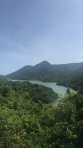
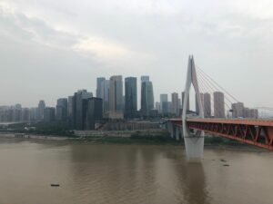
I took the picture above at city Chongqing in China, which is located on the upstream of Yangtze River and southwest of China. The bridge in the picture is heading  to a part of the city that resembles an island. It’s near the confluence of Yangtze river and  Jialing river, one of the largest tributaries of Yangtze River.  A little further east in the image is a wharf that separates two rivers in a shape of V.  On the river surface in front of the wharf,  one side is yellow and muddy Yangtze River water, the other side is jade-green Jialing River water. That obvious dividing line at the junction of water flow attracts many visitors.

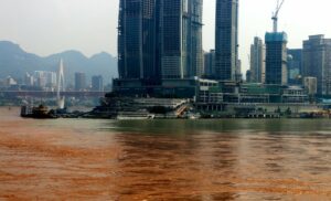
At then,  I just felt it’s a miracle and did not do any research to understand why this happens.  Now I know this formation is partly because of a heavy rainfall in one upstream despite the dryness in that of the other.  In essence,  the color difference is caused by different water composition especially the distinct sediment and silt content in the two river. Thus, when the raining season come, these difference would highlight out.

The Morris Canal


This is a photo of the Rockaway River, just a minute walk from my house. I have always been around the river my entire life, but I never really took the time to research about it until now. I have always seen a sign saying that the river is a part of the Morris Canal, but I never knew what that meant. The Morris Canal was mainly used as a way to transport coal from Easton, PA and across the Delaware River to Phillipsburg and then over to Jersey City in the 1800s. The specific area of the river by my house was used as a mule bridge to haul the boats onto the canal. I never thought this little river could be used to transport such important materials that helped industrialize the state that I live in.

Tai Tam River

Back home in Hong Kong, I live near the ocean, but not too far there’s a river. This summer I rode the bus only for a few minutes and hiked about 15 minutes to this pool and waterfall. I hiked along the river and had to cautiously walk downhill on a very rocky and steep path. Having talked to a lot of people about Hong Kong, they all view Hong Kong as a busy city. While this is true, as it is a business hub, I often think more about the South Side of Hong Kong (where I live.) The Southside has many hiking trails and beaches. What I love about Hong Kong is the mix of skyscrapers and shopping malls with nature. What was interesting about this river was that the start of the trail was off to the side of the middle of a very busy road. It was kind of an abrupt interruption for the busyness of Hong Kong. It was weird that one second I could be swimming in a pool that was silent except for the crashing of the waterfall, and the next I could be back on the street with people in a hurry to get to their job. This river is very closed off my towering walls of rocks. This made it so when I was there, I felt like I was in a completely different world. While I was in this river, I had no concept of time or even where I was. I felt completely thoughtless and only focused on the present, which was being in the river.

River Dawn


After I made the coffee this morning I noticed the sky in the east starting to look pretty interesting so I went down to the bridge about a 1/2 mile from home and just sat for a while drinking it in (my coffee and the scene in front of me). As Thoreau wrote in A Week on the Concord and Merrimack Rivers at this very time of year, “he who hears the rippling of rivers in these degenerate days will not utterly dispair.”

Seasons of the Mississippi

These pictures are from the Mississippi River as it runs through my hometown. The first picture is in late summer, as evidence by the very low water level of the river. In the spring when all the melt runoff from the snow flows into the river, the river is much higher, and causes flooding along the banks, which in bad years can cause flooded homes and closed roads along the riverbank. The second picture was taken in the winter (evidence by the snow). Due to the nuclear plant about a mile away from where this picture was taken,  the river remains mostly open and unfrozen  for the winter.  It’s not uncommon to see large chunks of ice go floating down the river, but the river itself is unfrozen.

The Nile River and Ancient Egypt

When I think of rivers, one of the first rivers that comes to mind besides the Delaware and the Hudson is the Nile. I remember learning about the Nile River during ancient civilizations class in middle school. The Egyptians and their neighbors utilized the river for food, water, resources, energy, and transportation. An entire civilization’s survival depended on this one giant river. Since there was barely any rainfall in the deserts of Egypt, the innovative Egyptians used the Nile to help create fertile land for growing crops with silt deposits, or irrigation canals that led the river water to the soil. The Nile alone is responsible for ancient Egypt’s rise as a thriving civilization with successful agriculture and a surplus of trade. It is remarkable how the Nile, the longest river on earth, seems timeless. It has always been a reliable geographic feature for Egypt since ancient times; and, the river continues its huge impact on Egypt as humanity and innovation keep evolving.

« Older posts Newer posts »

© 2025 What is a River?

Theme by Anders NorenUp ↑