Author: Matthew Lewis

Snow Chute Rivers

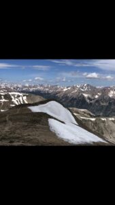
This picture was taken at over 14,000 feet in colorado on July 25th. As you can see there are many patches of snow that remain on the mountains. Not only do these snow chutes look like a bunch of rivers, but they actually turn into rivers as the melting season continues. Each one of these chutes creates there own little river as they melt, and the melted snow feeds into bigger and bigger rivers. These “little rivers” are the backbone of some of the major rivers in the west.

Boat House Row

Over fall break I took this photo of boat house row. Boat house row sits on the Schuylkill river in downtown Philadelphia.  I thought it was interesting how calm the water is in this picture, and I feel like the boat houses amplify the presence of the river.

Low Water Levels

While driving home for fall break, I noticed that the Delaware River water level was significantly lower than when we went on our paddle trip. The image above is the main river 5 minutes away from my house, and I was surprised by how low the water level is in this river was as well. You can see where the water normally is.  The lack of rain over the past couple months is showing across all bodies of water in the area.

Delaware River Canal

This is a picture of the canal that runs parallel to the Delaware River.  Construction for this canal began in 1829, and was used for many years. Mules would pull coal barges down the river. When we went on our float trip down the river, we were able to see the canal. I find it interesting that not that long ago, this was an effective form of transportation.

Lumberville- Raven Rock Bridge


This is a picture of the Lumberville- Raven Rock Bridge on the Delaware river. This bridge is about 30 minutes from my house, and is a pedestrian bridge, meaning it does not accommodate vehicles.  Construction for this bridge started in 1853. I find it interesting that it has survived all these years with minimal damage from floods/other weather events.

Little Tennessee River

This picture was taken at the mouth of the Little Tennessee River in Tennessee.  This area specifically is called lake Tellico, and it is a man made lake. During the Great Depression, building dams was part of FDR’s “new deal”, and the goal was to create more jobs and create hydroelectric power sources. During the 1930s, the Little Tennessee River was damed up, and as a result, Lake Tellico was formed. My Grandma lives on Lake Tellico, and my family and I visit her every summer and jet ski on the lake!

Mount Baker Lake


This photo was taken in Washington State, in the Cascade range. The mountain you are looking at is called Mt. Baker, and it is actually a volcano.  This picture was taken in mid-July while on a hike around the lake. While I couldn’t manage to find a photo of one of the rivers in the area, Mt. Baker is a glacier, and produces large amounts of runoff. It stands at almost 11,000 feet, and the elevation in this picture was around 3,000 feet, so the elevation gain from the lake to the top is massive.

Mountain River

This is a picture of a river named “The Snake River” and it runs directly parallel with the base of small resort in Colorado named Keystone. Keystone sits 10 miles west of the continental divide. If you can’t tell by the photo, the river here is running towards the photographer. The Snake river is made up of water from snowmelt, and runs extremely fast in the late spring/early summer, and slower in the later months of the summer. Some of the snow melt from the continental divide feeds into this river, but there are also many other smaller rivers (tributaries) that feed into this one, making it one of the larger snow melt rivers. This river along with many others from the continental divide and other ranges feed into a large lake named “lake Dillion” which serves as the water supply for Denver.

© 2025 What is a River?

Theme by Anders NorenUp ↑