Introduction
Now that the social and political constraints have been discussed, understanding the technical components of the project will help to establish the feasibility of this project and areas that may need to be further examined. Within this technical context, we will establish the overarching framework, systems, dimensions, ADA considerations, structural challenges, design, and materials of the Bridging the Gap project. All these determinations were made from peer-reviewed resources and conversations with Lafayette faculty members. This proposal is meant to provide a framework for future work to develop over time. Our mission is a design that focuses on the local Easton community while providing a more accessible and safe way of connecting the two communities. In other words, though the specifics of the design itself and technical considerations may shift, we hope that this proposal can provide a framework for establishing a more just and resilient connection between the Lafayette and Easton communities.
The Four Components
This project is composed of four main components. There are many regions to consider in the area between the main campus and the Williams Visual Arts Building, making room for many creative ways to envision the pedestrian bridge placement. The four components include the trail revitalization, the trail extension, the Ahart connection, and the Bushkill connection.
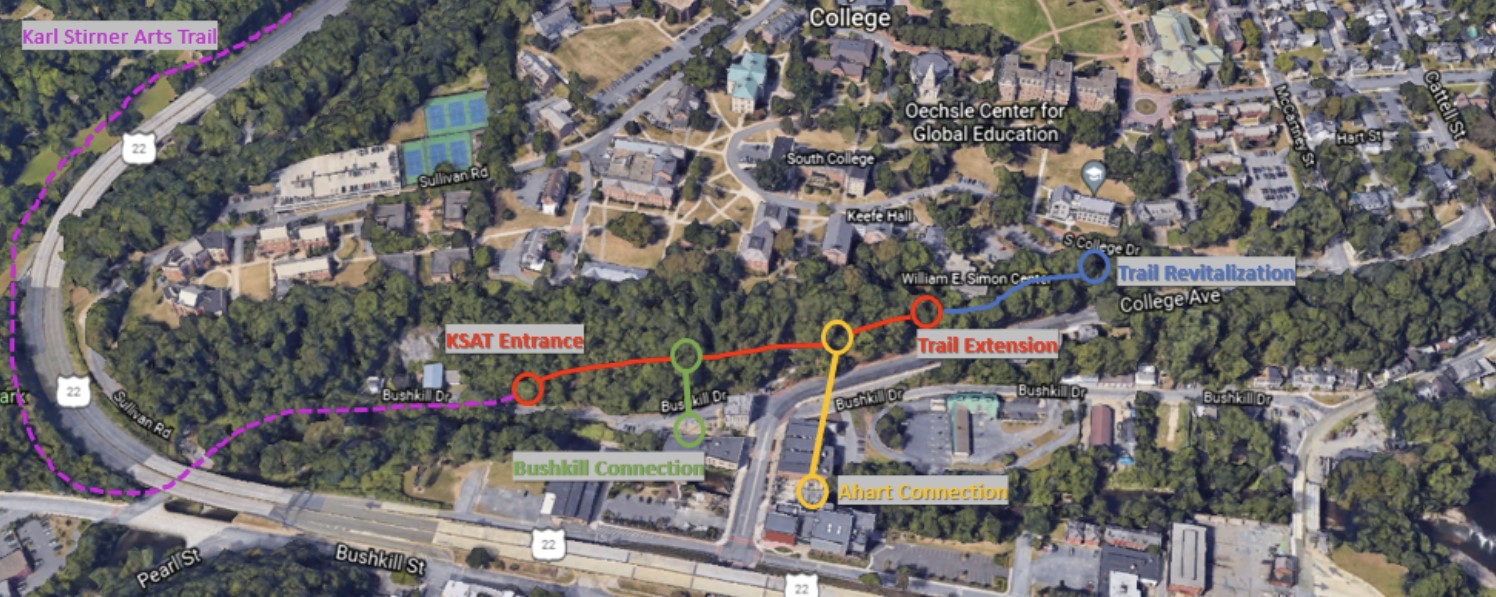
Figure 14: The Four Components
When discussing where the four components of the project will be implemented, we were careful to think about whether the community may feel welcome to access the infrastructure. Previous proposals for connections have been perceived as exclusively based on their purpose, presentation, and procedures. For example, the “Skyway” elevator proposed in 2016 was viewed as a frivolous project that would seem uninviting to the Easton community as it connected to the center of the Lafayette campus. Professor Wilford-Hunt has also described a situation in which a local firm created a design for a bridge without consulting anyone including Lafayette and Easton residents. From Professor Wilford-Hunt’s example, we have realized that establishing a rigid design of this project would only lead to its failure. The ultimate design establishes a trail network that connects to the Karl Stirner Arts Trail (KSAT) and ventures further into the campus allowing public access to green spaces and a natural atmosphere. This is something that is highly lacking in lower socio-economic status (SES) neighborhoods. Separating the framework of the project into these four focus areas has helped us to manage research and development for the feasibility of each constraint.
Trail Overview
One of the most valuable aspects of the bridge project is the trail network. The trail network includes the trail revitalization and the trail extension. The trail revitalization involves the reworking of the path that branches out from S. College Drive just south of the Oechsle Center for Global Education and the Zeta Psi Fraternity house. This trail goes west for an estimated 320ft until it reaches the southern end of the William E. Simon Center. The approximate, average width of this trail is 15ft. The current purpose of this trail is for facilities operations workers to access the back side of the William E. Simon Center.
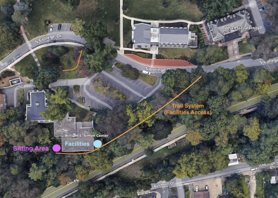
Figure 15: Preliminary outline of trail behind Simon Econ building
Although there is a way to exit the trail on the southwestern corner of the William E. Simon Center through a sitting area, the current state of the trail along the southern wall of the building is too narrow, overgrown with plants and dangerous. Therefore, the very first proposal is to make this existing trail fully accessible. That would involve either paving or generally flattening the path so that it can be walked on comfortably. Also, as the path approaches the William E. Simon Center, much of the vegetation must be cleared out. If the path right behind the building remains too narrow even after clearing it out, there may be a need to construct a walkway to supplement the path width. By completing these steps, this trail should become safely accessible. The overall reason to revitalize this trail is to lead into the creation of the trail extension.
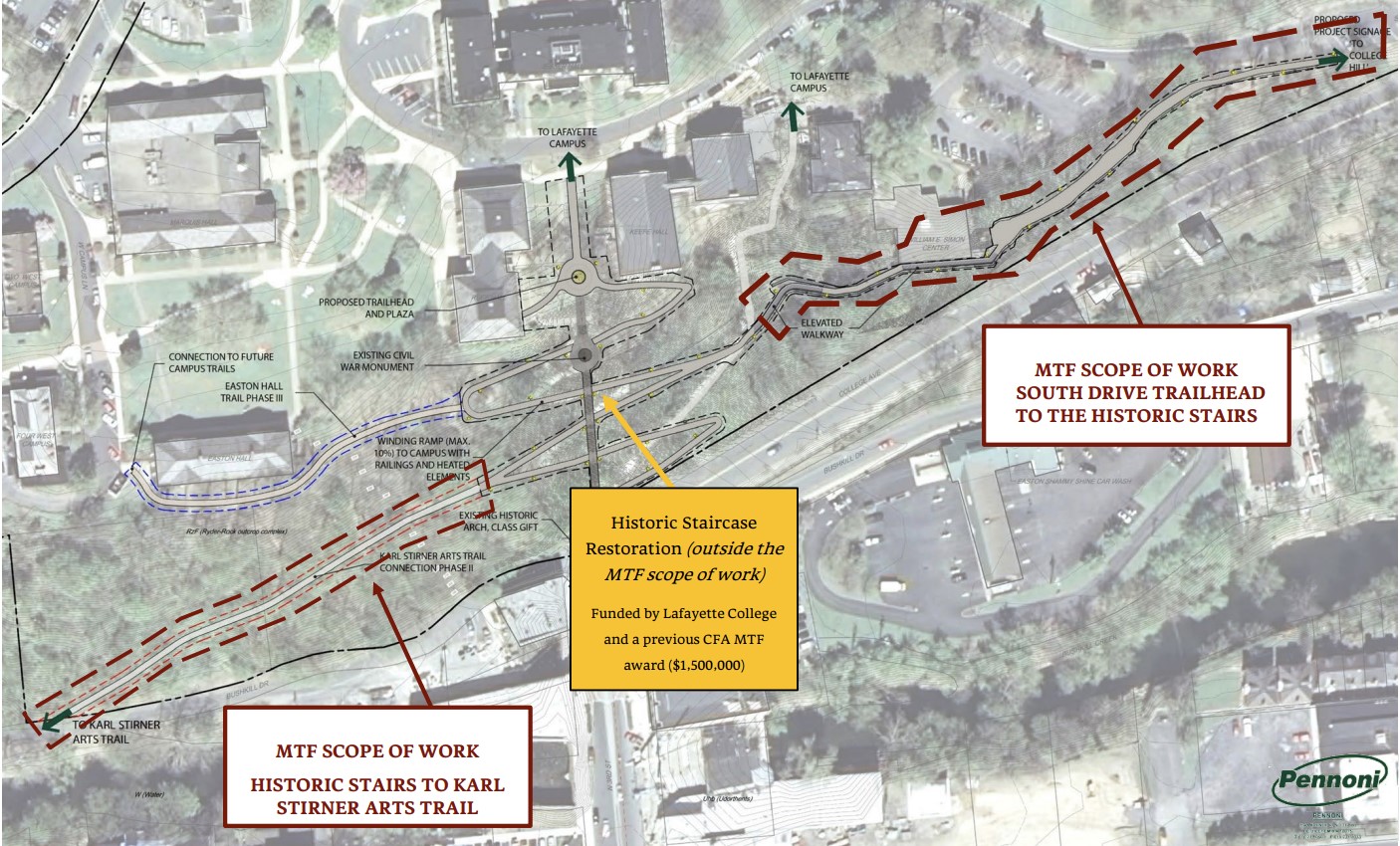
Figure 16: Trail revitalization and trail extension
The trail extension will serve as a continuation of the trail that ends at the William E. Simon Center. By constructing an elevated boardwalk, the trail can extend west all the way to the east side of the stone steps. Because the ground along the hill between the William E. Simon Center and the stone steps is not even, an elevated boardwalk can make a safe and smooth pathway. This section of the elevated boardwalk will be approximately 320ft in length. Once the trail extension reaches the stone steps, it will connect with the stone steps at the location shown in Figure 16. By using the stone steps as a connection point, the trail extension will be able to continue on the west side of the stone steps. This section will once again be an elevated boardwalk that runs along the hill until it reaches the Karl Stirner Arts Trail. This section of the elevated boardwalk will be approximately 500ft in length.
Putting this all together, this trail network will connect S. College Drive from near the Oechsle Center for Global Education, all the way to the Karl Stirner Arts Trail on Bushkill Drive through the revitalization of the existing trail and the construction of the elevated boardwalks that will be connected by the stone steps. We are happy to see that this trail network is a part of Lafayette College’s proposal submitted on July 24, 2021, to the Multimodal Transportation Fund in Pennsylvania. As part of the Easton/College Hill Escarpment Multimodal Improvements Project, this trail network is likely to come to fruition. We would now like to discuss the ways in which we can expand on this existing idea.
Bridge Systems
The trail network connecting S. College Drive and Bushkill Drive has the potential to serve as a starting point for a way to provide benefits that are still currently lacking. One of the main issues present between the main campus and the arts campus is the difficulty of crossing College Avenue as a pedestrian. Secondly, the ascension and the descension of this hill is unnecessarily challenging, especially when using the stone steps. The stone steps can also become a hazard in harsh weather conditions. By using the trail network as a starting point for a pedestrian bridge, some of these issues can be resolved while also creating a tangible representation of the growing connection between the city of Easton and Lafayette College. The first proposal is the Ahart Arts Plaza Connection, which will connect the elevated boardwalk on the right side of the stone steps to the Ahart Arts Plaza. The second proposal is the Bushkill Connection, which will connect the elevated boardwalk on the left of the side of the stone steps to the Don Juan parking lot area. These two proposals will be described in detail below.
Systems’ connection
As stated earlier, the trail and bridge system will be connected with their designs relying heavily on each other. The large slope and small distance between the hill and College Ave, the heavily trafficked and state owned road, presented a serious design challenge that led our group to create multiple proposals with the help of Lafayette faculty who are well versed with the geography of the region. The main constraints of our project remain intact but the specific locations of each of the four components shift slightly. The first proposal, that we have spent more time developing, is the Ahart Arts Plaza proposal. The second and less researched proposal is the KSAT proposal, also referred to as Design A and Design B. In the following sections, the location, dimensions, and challenges of each location will be discussed in detail.
Design A: Ahart Arts Plaza Connection
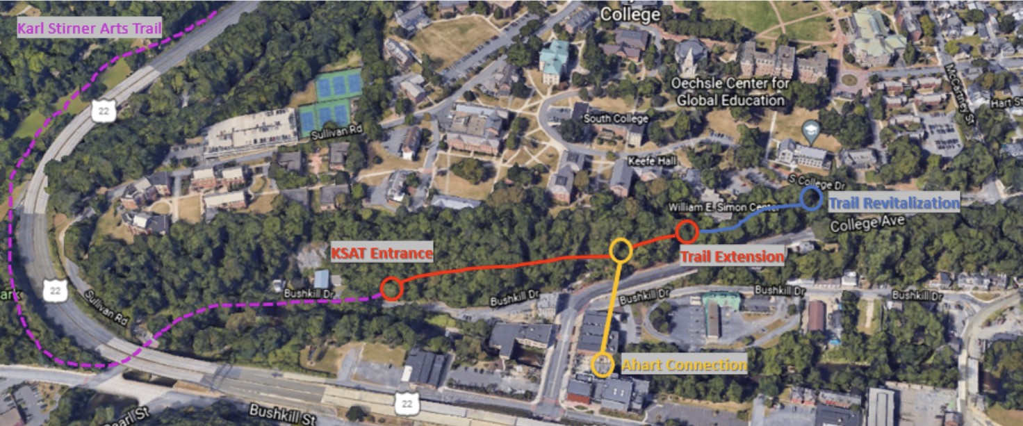
Figure 17: Ahart Connection shown in yellow.
The Ahart Arts Plaza Connection is a pedestrian bridge that will begin near the connection point of the east side of the stone steps and the connecting trail extension. Specifically, this starting point should be directly north of the Ahart Arts Plaza. Civil Engineering Professor David Mante stressed the importance of keeping the distance of the bridge as short as possible. If we are to connect the bridge to the Ahart Arts Plaza, the bridge must go directly north from the Ahart Arts Plaza and over College Avenue as depicted in Figure 17. Based on the exact location of the entry/exit point for the bridge on the Ahart Arts Plaza and on the hill over College Avenue, this bridge can span anywhere between 310-350 feet. Because the elevated boardwalk will be roughly 50 to 60 feet above the Ahart Arts Plaza, the most straightforward way to lift or lower people is placing a vertical system at the Ahart Arts Plaza, such as a stair and/or elevator system.
The technical and design properties of this bridge will be influenced by many factors that would satisfy all factors previously outlined. Some major factors include the scale of the bridge (how it stands out in its context), its entry and exit points, its potential additional connections, and the presentation based on material and aesthetics. As mentioned, accessibility and inclusiveness are some of the most important characteristics of this project. This would mean creating a stable footing as well as maintaining a gentle slope compliant with ADA (see ADA Considerations). After completing this requirement, there may be other opportunities to make improvements to the safety and overall experience of pedestrians. Increasing the visibility between pedestrians and potential cars passing through S. College Drive is one such example.
Furthermore, after meeting with Professor Mante, we came to the same conclusion that the bridge portion should be over a location that can include ground supports every 50 feet. In this case, the bridge would span directly north from the eastern end of the Ahart Arts Plaza. To encourage the Easton community to make use of the bridge and its connected trail, the Easton Bridge landing is placed at the Ahart Arts Plaza as it is an open space and a nice meeting area that the community already makes use of. We had briefly considered connecting the bridge directly to the Visual Arts Building but decided against it, as it could feel exclusionary towards Easton residents by housing it inside a Lafayette building. According to Professor Gil, the plaza is a nice meeting area with much potential for growth, as it has benches and is above the Bushkill Creek which can be incorporated in the design of the bridge. There is also parking on either side of the road further increasing accessibility for those that wish to drive, park, and walk around the area.
Although this design is one of the most ideal if not the most ideal form of an accessible footbridge coming off the hill of Lafayette College, it will have to overcome some major obstacles in order to come to fruition. One of the major challenges that this design will face is the construction of the bridge section over College Avenue, which is a road controlled by the Pennsylvania Department of Transportation. Because of the busyness of the street, it will be a challenge to receive approval for constructing over the road. We believe that there may be ways to make this process more feasible by using creative construction methods. For example, by using a modular construction method, the majority of this bridge’s components can be built offsite and then quickly assembled onsite to cause as least disturbance possible to College Avenue as possible. Another obstacle is in making the elevated boardwalk and trail section of this pathway to be ADA compliant. We will elaborate on this in ADA Considerations.
ADA Considerations
One of the biggest challenges we will face on the technical front is to make this entire walkway compliant with the American with Disabilities Act of 1990 (ADA). First off, we will have to calculate the slope of the existing path behind the William E. Simon Center and the Oechsle Center for Global Education. This dirt pathway will require renovation for both aesthetic and general safety purposes to ensure those with disabilities (e.g., wheelchair users) can comfortably access the pathway.
The elevated boardwalk will curve out to College Avenue roughly at the same elevation as the path behind Simon in order to maintain a grade of 5% or less for ADA accessibility. Once this walkway has left the trees, then the bridge portion can be built over College Avenue. This bridge will span directly south until it reaches the back end of the Ahart Arts Plaza. Because the bridge slope cannot descend too much to conform to ADA, we suggest that an elevator and stair system be built on the Ahart Arts Plaza.
After meeting with Professor McGuire, we have realized that making the elevated boardwalk and trail portion of this pathway will be difficult to make ADA accessible. Based on rough readings, the elevation at the S College Drive entry point of the path is 60-70 feet above the point at which the bridge will meet the hill. The distance between these two points is roughly 670 feet, which means we only have an approximate allowance of 55 feet in the change of elevation. We are hopeful that we will be able to compensate for this by adding additional height to the bridge as it reaches the hill on College Avenue. Because the bridge will only need a rise of about 15 feet from the Ahart Plaza to the elevated boardwalk on the hill, we may be able to increase the slope of the bridge to ease the slope of the elevated boardwalk/trail portion.
Furthermore, according to Lafayette College’s proposal to the Multimodal Transportation Fund, ADA compliance is not prioritized along the trail network. However, we believe that it is still worth considering when it comes to the final design stages especially because the bridges will have the capability with the help of an elevator and stair system.
Design B: Bushkill Connection
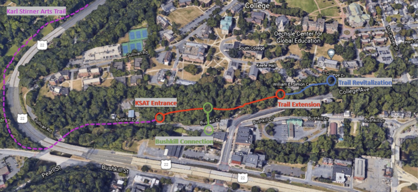
Figure 18: Bushkill Connection shown in green
The Bushkill Connection is an alternative solution to creating an accessible connection between the main campus and the arts campus. The connection will be a pedestrian bridge that begins along the trail extension on the west side of the stone steps. The bridge crosses over Bushkill Drive and will end at the Don Juan parking lot area, spanning a total of approximately 130ft in length. According to Professor Mante, this bridge would be much more simple and ultimately more cost effective compared to the Ahart Connection bridge. This bridge bypasses the stone steps and creates a much smoother commute between College Hill and downtown Easton. Furthermore, by creating the entry/exit point near the Don Juan parking lot, those who would usually opt to cross College Avenue at McCartney Street instead of taking the stone steps can now cross the road on the recently constructed crosswalk on North 3rd Street in front of the Williams Visual Arts Building.
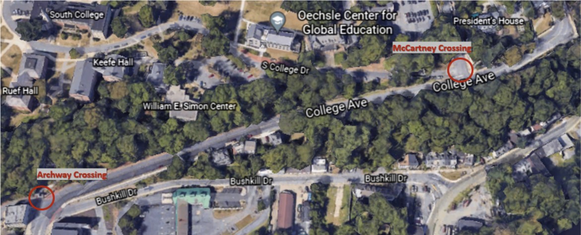
Figure 19: Common College Avenue crossing zones for pedestrians.
Materials
Because the aesthetic presentation of this bridge is a key component of this project, we do not aim to limit any potential designs. However, we would like to recommend a few options as a starting point for consideration. The first recommendation would be to use stone as the dominant material for the bridge to complement the stone steps, as well as many of the buildings through Easton. The stone steps blend naturally into the green hillside of College Hill and thus can be a strong candidate. Stone is also structurally sound for this type of project where supports can be placed underneath most of the structure (Svrjcek). Brick and mortar could also be incorporated with stone, which could be a complement to many buildings on campus.
Steel is also a commonly used material for bridges. Steel is very sustainable in terms of its longevity and its limited impact on the environment which can be attractive (AISC). Much of the structures in the downhill arts campus incorporates steel in its architecture, thus making steel an aesthetically matching candidate as well. The third recommendation is fiber reinforced polymer (FRP). Although this material is the most unconventional, its properties allow it to be structurally sound while being very adaptable to different styles of presentation (Smits, 2016). FRP design and production has been rapidly improving over the years as is being used for an increasing number of projects (Smits, 2016). The production of this material is especially friendly to the environment compared to other conventional materials, in the specific case that renewable materials are used. (Smits, 2016). This material can be modified in ways that resemble other materials so that it does not stand out in any unintended ways (Smits, 2016). The use of FRP can be a symbolic view moving towards more innovative and sustainable solutions to long unchanging methods of construction. After the consideration of cost and durability, another important factor to consider for the material is the ability to be 3D printed or constructed off site. If major sections such as the main structure and deck could be built offsite, on-site construction will be much faster than putting the bridge together piece by piece.