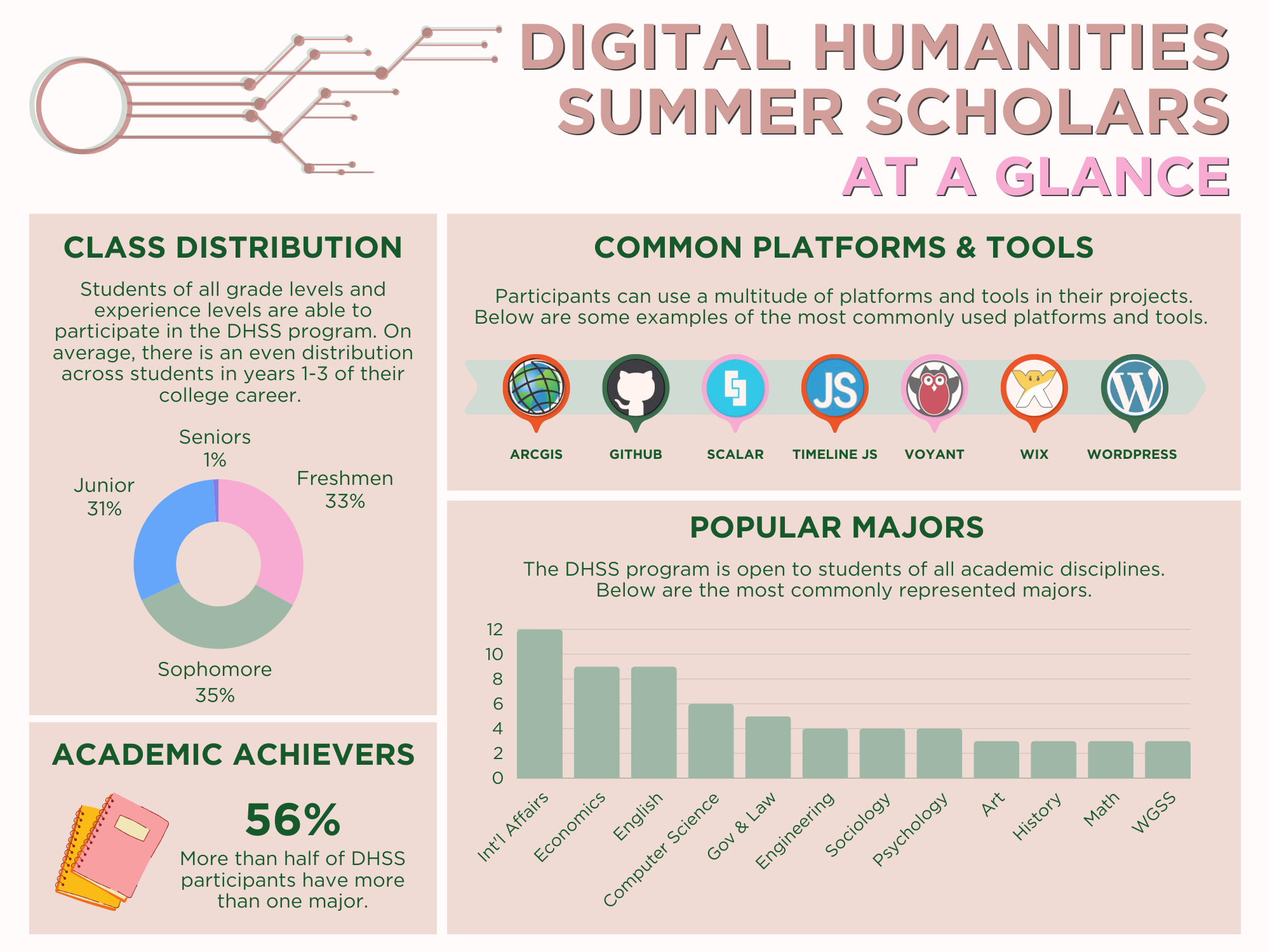
Third Reflection (Camilla)

In our class discussions, we have tackled the perceptions of Digital Humanities as a predominantly white, male, form of scholarship that lacks a critical lens. However, I strongly disagree with this statement, and believe that the digital humanities projects that myself and my peers are working on do the opposite: they promote understanding of history, of stratification, ability, refugee migration, race, sexuality, and in my case of stereotyping and negative impacts of excluding policies based on culture and ethnicity. Our projects strive to be intersectional, and that was one of the values that we came up with as a team during the very first day that we all came together to embark on this journey of exploration, research, and discovery. What does it mean to be intersectional? Before I started college, I didn’t fully grasp the meaning of this word. In fact, the dictionary on my computer still insists that the word doesn’t exist, and highlights it red every time I write it in my class notes or in a paper. To be intersectional means to understand how multiple factors can influence an outcome, and how things are connected. Race, gender, socioeconomic status, etc, do not operate as singular entities. Rather, they affect and influence one another, and can and should be associated to understand how they are all related and impactful. Over the course of this research internship, I strive for my research to not have one singular facet, I hope that I can stay honest to my work and stay objective. I am not Sami myself, and most research papers I have read on Sami are not written by Sami scholars, but rather, they are written by people who wish to learn more, who wish to understand, and who strive to teach and convey powerful and humanizing messages. I too hope that with my research I can help others understand the impact of government interference on indigenous groups, specifically how categorization and regrouping form images of Sami that do not convey the various parts of Sami culture. Not every Sami is a reindeer herder, and they are not all nomadic–assuming that they are, and for example, relocating them thinking it isn’t a problem since they move around anyway, not only influences their abilities to interact with their own traditional lifestyles, but the way that Sami children living surrounded by other Swedish children are perceived by their peers. It is important to understand that cultures evolve, that they are not static, and that not everyone in a culture that isn’t one’s own is the same, or lives the same life.

In “Pedagogies of Race: Digital Humanities in the Age of Ferguson,” by Amy E. Earhart and Toniesha L. Taylor, the authors ask what digital humanities would be like if they focused on social issues and were “transformatively critical.” I interpreted the latter term to mean being critical of research done through analysis, but also in a way that is transformative, or changing the way we look at social issues and information, with a goal of changing perspectives and asking more questions. Earhart and Taylor describe a digital project through Texas A&M University and Prairie View A&M University, both state universities in Texas, Texas A&M being predominantly white, while Prairie View A&M is a Historically Black University (HBCU). Their project of digitizing racial conflict titled White Violence, Black Resistance is relevant today, and compares with racial violence against African Americans today such as in Ferguson, MO. Their work, while historical in nature, has contemporary applications. In addition, Earhart and Taylor describe how the media is a strong source used to share experiences, and digital humanities broadens that field of expression and sharing. Having access to digital humanities in the classroom later has real world applications, and helps people analyze current events and form understanding of their roots and comparisons between the modern age and the past. Ultimately, this project partners two universities with contrasting racial populations. Having them work together expands their resource bases, especially considering that Prairie View does not have the same funding for library space and archives that Texas does. Their project builds bridges, shares multiple perspectives, and looks at history by revealing information on black resistance and white violence, rather than concealing it.

When I think of digital humanities, I think of collaboration and opening up discussion and eliminating barriers. I think that digital humanities have a strong impact on scholarship, and have a lot of power to induce change, so I am with the movement that Roopika Rasam describes in “Beyond the Margins: Intersectionality and the Digital Humanities,” it is time to #transformDH. She explains the assumption that digital humanities do not think, they just do. But if we are careful with our defining and the data we choose, if we understand who we are leaving out, who we are marginalizing, we can be more intersectional and true to the data we are using and the projects we are creating. In my project I detail the ways that the Swedish government has defined Sami and therefore marginalized those that do not fit the description. When we do research as digital humanists, we have to be careful not to do the same. I know that my project is from an outsider’s perspective, but being an outsider isn’t always a bad thing, it must just be recognized for what it is. My goal is to include many realities in my project–realities of reindeer herding Sami, Sami youth going to Swedish schools, Sami youth going to Sami schools, Sami that herd part time, and Sami who do not herd at all. Will I be able to include everyone in the narrative? Unfortunately, it is likely that I will miss part of it, but the amazing thing that I see happen through collaboration is the ability to discuss and learn more over time and from one another. I recognize that my project isn’t going to be perfect–no research is, it is a process–but I plan for it to be a step forward in the communication of acceptance and understanding.

Estrato or Stratum?


On Domenico Fiormonte’s Toward a Cultural Critique of Digital Humanities

The first page of this text highlights exactly what I wanted to in my first reflection for DHSS. It critiques the “indisputable Anglo-American hegemony in the academic research field”. As I stated in my first reflection there are very few developing countries that have strong research. This is due to a ton of intertwining reasons from lack of funding to lack of research based colleges, but is inevitable a problem in the academic world. If all the things people are studying comes from the US then there is a lack of perspective in the research community. This is precisely why I wanted to do my project on somewhere outside of the US; it’s the reason I chose Colombia. Furthermore, there seems to be this perceived idea that developing countries need a lot of help and that the only way to ‘fix’ them is through the lens of already developed countries. This is simply not true! “Peripheral cultures do not need any revenge or, worse, any seat at the winner’s table.” As I wrote in my first post, why can’t Latin America succeed through different methods and dissimilar conditions?

The next set of questions the author asks can also be related to my project. Throughout the process, I’ve asked myself how I would be able to relay this information to scholars back home since it’s all in Spanish. There’s no doubt that the language of research is English. There’s no doubt that the language of computing, or at least digital tools, is also English. This leaves a very small space for those cultures and languages that want to make it in the big leagues but aren’t Anglo-American. What’s worse, there really isn’t a push for other languages to be promoted. But the real problem is that these tools are created out of a specific context. Technology is not neutral to its context. Clear examples of this are the inaccessibility of things like accent marks and the .edu domain to colleges and institutions outside of the United States.

The crux of what we’ve been debating so far in class can be seen in this quote: “it appears that digital humanities is the victim of a continuous paradox; demonstrating an ability to keep up with technologies (and with their owners and gatekeepers) and, at the same time, not to become subject to them.” Here we combine what we’ve been saying during the first two weeks about the rift between the humanities and it’s digitalization with an even more complex layer: the control of digital methods.

But the author doesn’t only stop with language. He goes on to explain that even desktop icons are also a form of cyber-colonization. That being said I wish he would’ve explained in greater detail the full effects that this could have, as he did with language. A second critique of this reading is when the author overlaps two maps; one with linguistic diversity and another with World GDP. He argues that “cultural richness does not necessarily match material wealth”. While I do agree that this is true, I do not think this is a correct way to prove it. “Cultural richness” is much more than linguistic diversity.


On Roopika Risam’s Beyond the Margins: Intersectionality and the Digital Humanities

This second reading is a bit harder to pull apart. The author starts by suggesting a division between theory and practice. This involves questioning how the Digital Humanities represents each. However, the author goes further by asking who is really involved in the construction of these projects and who are they for, just as the reading explained above.

The main argument, though, is based on intersectionality. Intersectionality is the “look beyond the race-class-gender triad described… [to include] additional axes of difference including sexuality and ability”. Similar to the previous reading, the author looks at why having the tools used in Digital Humanities in another language creates a barrier. If we truly want to understand the works of “black, women, [and] third world” scholars we need to be able to adopt their language and discuss in their own terms or else we limit the true expression of these scholars. Once again, my project is an example of this. There is no ‘real’ word that describes estratos in English. The closest approximation is Stratum or its plural, strata. Yet, that doesn’t really describe the full cultural connotations of the word. For example, it wouldn’t make sense to call someone ‘strata 1’- in English it is not a description of a person, but of a set of physical locations. In Colombian Spanish, socioeconomic zoning has made it relate to more than just a place- it is also an indicator (socially) of wealth, income, etc.

Another interesting argument Risam makes is about the way difference is portrayed online. Although cultural representation has been around for a long time, it is only with the internet that it has been able to gather widespread acceptance. As such, many different bodies, both public and private, have started using this to their advantage.

The racial makeup of coding is a good example of representation in the Digital Humanities. It is mostly white middle-class men who have the most access to coding. Who codes is just as important as what is being coded. But it isn’t enough to just give a minority a computer a say “code”. We must understand that the coding process itself is in between racial and gendered lines.

From what is being said in the reading, there doesn’t seem to be much backlash to this idea of diversification of DH. Scholars do want both (maybe I should say all) sides to be engaged, but they aren’t giving anyone the tools necessary to engage. That is the heart of the problem. It takes a lot of willpower to give up privilege, especially in something like technology.

I want to end with the same way the reading ends: “There is no single way of being “intersectional” – instead, intersectionality privileges exploration and innovation in feminist praxis. And aren’t exploration and innovation at the very heart of digital humanities?

Third Reflection (Tedi)

When it comes to equality, there seem to be two general, at-war schools of thought. One, that true equality will be achieved through erasure of individual identity—that there is equality in reducing every author and artist to their most basic identifier: human. Symptoms of this sort of thinking including espousing epigrams like, “I don’t see color” or “The only race that matters is the human race.” Its competing theory entails the opposite- that true equality is achieved through an acknowledgment of individualism by validating the variety of the human experience. People and their works are acknowledged within the sociocultural ecosystem of their birth. Instead of claiming “I don’t see color,” one might recognize another’s blackness and that their experience differs from the white experience, instead of invalidating this experience by diminishing it through erasure. Instead of ignoring our differences, we see them; instead of flattening the human experience, we give it dimension and color.

But how do these two theories of equality relate to digital humanities?

Before I embarked on my Digital Humanities journey, I liked the notion that Digital Humanities could be inclusive through anonymity. The computer would serve as the great equalizer, rejecting the biases and prejudices that commonly plague the humanities (and academia in general.) In Digital Humanities, the creator would be appraised by their scholarly work—gender, color, and creed aside. However, after some thoughtful reflection, research, and article-reading, I tend to stray from my original conclusion. I don’t want my project to be viewed void of context, a piece of creation born and then immediately divorced from its maker. I want my viewpoint, politics, and experience to be considered in duet with my work. My website was made by a white, able-bodied woman, upper-middle class, transposed from her Southern megalopolis into a tiny Northern town.  I don’t want to erase my authorship of this project; instead, I want to own it. I gravitate more towards acknowledgment over erasure, recognition over refusal.

In the articles I read, feminists addressed intersectionality instead of perpetuating white feminism (which is hardly feminism at all.) They attacked a “neutral point of view” as being deaf to the systemic biases against women, people of color, those in poverty, and the disabled. “Listen to us!” we want to scream, “Instead of ignoring us! Hear our experiences and recognize how they differ from your own.” Part of my responsibility as a disability studies researcher has been to not speak over the voices of a marginalized people, but to allow them to speak with autonomy (and I’m doing my best to do so, to avoid the tantalizing “savior complex” role that so many seem to revert to.) It is not my place to scoff at or deny someone’s experience of racism or ableism, in the same way that it is no one’s place to demean or belittle my experience as a woman. Good allyship ensures equality through representation, not repression, of identity.

2017 Tool Reviews

Find three digital tools that you might use in your project. Provide a link, a summary, and both positives and negatives.  Include whether it has platform restrictions or limitations. Order the tools from most useful (the one you will demo for the class) to least useful for your project. If that distinction is difficult to make, note why.

Camilla Samuelsson

Google My Maps *

Google My Maps is a mapping tool that allows users to create their own maps by inputting their own data. The description page includes a step-by-step process of how to create a map, starting by adding a title, description, and then adding layers either by drawing them onto the map or importing data. This can be done using Microsoft Excel or other software. This tool appears to be relatively straightforward. I am not sure where I would receive information about latitude and longitude, but using addresses from different places in the cities I am researching in Sweden, I might be able to make a map showing Sami institutions, if I decide to get that detailed with my mapping. Either way, this tool is usable with Scalar and the map can be presented on a web page that I create, helping compliment my work. But I can also use it on its own, potentially zooming in on cities and providing descriptions of different city features and institutions through pop-up areas on the map, labeling different themes that way. This would remove certain parts of my idea, such as symbolic Sami identity, and would focus more on how the city represents Sami culture and on quantitative data, rather than qualitative data. I do not fully understand this tool yet. I do believe that it will take a lot of time to learn and will challenge me, especially in determining what to put on the map and how to get it to where it needs to be. Still, since Google Maps is already pretty detailed on its own, addresses and designated areas located through my research on these cities may be easier to input on this than on a tool like ArcGIS. I think that the difference is that on Google Maps, I can layout different places on a map and structure them to show recurring themes and importance, whereas on other tools the features can get more advanced and represent space over time and require programming skills that this tool does not require. The tool is not very customizable, as it is mostly data visualization, but different layers can be added. Using color coding and a side bar I can customize the representation of my data, but the map’s appearance seems to be pretty standard to what a Google Map looks like. https://www.google.com/earth/outreach/learn/visualize-your-data-on-a-custom-map-using-google-my-maps/

Scalar 2

Scalar’s goal is to expand “visual practices” and work with scholars to create media platforms and scholarship. Scalar is a template in order to create a “book” but from what I can tell from projects I have seen and reviewed, it appears to be a blog-like webpage with a lot of different uses available. It can allow me to visualize my ideas and expand on them through mapping, displaying images, and displaying my data in order to create a comprehensive site that is understandable and accessible to my audience (which I still haven’t determined). The Overview states that it is “as easy as blogging.” As someone who has worked with a few blogs over the past 10 years, I think this tool will be workable. The tool has built in tools to complete parts of the project such as annotating and embedding media content such as video, audio, and images. There are two forms of structure: paths and tags. Paths create sequences of content that work linearly, meaning that they connect one after the other. Tags are not linear, but group content. Tags are probably going to be my focus since my content will be series of images and other media that display Sami life, but that do not necessarily have a linear pathway.

I created an account on Scalar, and the page that popped up immediately directed me to create a new book. There are steps clearly displayed as to how to design a layout, create pages, and add media. It might take me awhile to figure out an efficient way to work on a book. As of right now, I think this tool aligns well with my research question. With a goal of visualizing Sami urban culture, using tags and basic Google Mapping (a challenge in of itself, in my opinion) to display my findings and represent the different Sami populated cities.

ArcGIS

ArcGIS is a digital mapping tool that can be used to analyze maps and visualize different events and places that have happened/are happening around the world. On the lesson page, users can learn how to make cartographic creations, analyze businesses, and analyze statistics. Lessons can help a user get familiarized and get started. For example, a lesson on ArcGIS online teaches mapmaking through exploring Hawaiian volcanoes. In order to use this tool, I would have to learn how to add layers to a map, add data to a map, and form pop-ups to make the map interactive and informative. While originally I had intended to use ArcGIS to create my project, my research question has changed from displaying migration overtime to analyzing city Sami communities. Therefore, GIS may not be the most useful tool for me, but could potentially assist me if I decide to make my mapping component more detailed. This depends on what kind of data I find on the cities I am exploring in Sweden. If I find data that can be displayed in a map—maybe as a way to explore the cities through maps—then this tool could be useful, but I am thinking that a webpage with mixed media and exhibits is more related to the goal I have in mind. I think that this tool would take a lot of practice as well, as I have never mapped before. Since my mapping goals at the moment are small and just a fraction of my whole project, I may benefit from using another tool instead. Still, I see that ArcGIS has many different layers to it and what seems like endless possibilities and ways to use it.

Tedi Beemer

Scalar- http://scalar.usc.edu/

Scalar seems to be more in line with what I’m looking for in a website-design tool. The program doesn’t require the user to build from scratch or to learn a coding language, which is a feature that I really appreciate. The site is incredibly customizable and allows the user a wide range of choice in deciding how to represent their data. Naturally, there are more restrictions in this format since there’s less building and more designing, but I don’t find these limitations to be hindrances, but rather allowances—letting me pick from prearranged formats is simpler for me, the designer, and I don’t feel incapacitated by the relatively limited choice. I say relatively limited because, of course, Scalar still presents a plethora of options for customization. My debility with internet/web design leads me to predict that this tool will still challenge me, though less so than learning to code would. I don’t have a full understanding of this tool; in fact, the cornucopia of options on Scalar overwhelms me, so I imagine that I could master this tool with a little more investigation.  This tool would not help me answer my essential research question but would help me present my essential research question in the way that I desire to. What I like most about Scalar is the emphasis on publication of e-books; my ultimate project goal is to build an e-book/web documentary.

Positives: This format allows for a high degree of customization but provides preset formulas for those unfamiliar with coding and allows for research to be presented in a chronological/narrative format.

Negatives: The user doesn’t get complete control over customization, the URL must be prefaced with a Scalar tag, and the e-book format may not be right for every research project.


WordPress- https://wordpress.com/

WordPress is fundamentally more similar to Scalar than to Thimble; WordPress doesn’t require the user to code, but rather presents them with preset formats and formulas for ease of editing and design. This tool interacts with data in a similar way as well, by allowing the user to present their data in a method of their choice. Though neither site helps to answer an essential research question, the site presents important information in an aesthetically pleasing and customizable fashion. This tool may challenge me slightly less than Scalar, since I do have experience using similar sites like Wix. One crucial difference between the two sites is presentation method. Scalar sites, self-designed “e-books” allow for a more fluid, narrative style of research delivery than WordPress, which is better for more stagnant projects, ones which require less emphasis on the chronology of information. While I think that Scalar would be ideal for my DH project, I can see WordPress being far better for an online shop, a restaurant, or a small business. While Scalar gravitates towards research and academic products, WordPress is less specific and more general. The broadness and genericalness of WordPress makes me think that Scalar would be more suited for the type of research I’m doing and how I want to present it. WordPress, however, has no evident gaping flaws, and may be perfect for someone with a different project or vision.

Positives: Allows for a high degree of customization, great aesthetic appeal, very easy to use and edit.

Negatives: Limited to preset themes with user modifications, static method of presenting information, widely-used, big limits to what is customizable.


Mozilla Thimble- https://thimble.mozilla.org/en-US/

Mozilla Thimble is a website building program and a self-described “online code editor.” I selected to review this tool because I want to build a website for my project. While I like the amount of choice that this site allows for users, building a website is really only feasible for those comfortable with CSS, HTML, and Javascript. I felt out of my league attempting to create a website with this tool because of my little knowledge of coding language and script. For someone with a background in any of these languages, or the patience to complete complicated tutorials, this would be a great site to build a website (almost) completely from scratch. Since I admittedly place a lot of emphasis on website aesthetic, this is probably not the tool for me. If you’re looking to dabble in coding, want the challenge of building a website from scratch, and are somewhat apathetic about your site’s visual appeal, then this could be the tool for you. After all, the information on a site is far more important than the site’s aesthetic, and I acknowledge that my emphasis on site design is somewhat frivolous. Learning this tool would definitely be a challenge; for me, I feel as though it would be a challenge too great, as I would prefer to focus my energy and resources on researching my topic rather than acquiring coding knowledge. Any quandary or qualm I have with this site is purely due to my belief that this tool would be ultimately unhelpful in designing my project; otherwise, I find the site to be well-designed, easy to navigate, and ultimately appealing.

Positives: Almost full control over website design, lengthy tutorials that actually teach how to code, project will be entirely unique.

Negatives: Must code to use, websites start essentially from scratch, requires great effort to design even a primitive site.

Maria Ahmed 

Omeka*: http://omeka.org/

Omeka is open source software that allows you to publish and upload data as exhibits. With in Omeka, there are different plugins that you can use. I want to use Neatline for my project. Neatline is exhibit builder that allows you build interactive maps, annotate images/maps and use collections from Omeka exhibits. Neatline makes it easy to tell a story and makes it easy for users to interact and follow the story visually. I want to use this platform to share the stories and the movement of some Somali refugees in the US.

Positives: you can upload data for example I can upload exciting maps, so I don’t have to use the default maps in the site. You can annotate documents, so your visual map has information it needs.

Negatives: when you are using the maps in Neatline, you can search for location, you have to manually find the place you want on the Map. This could be hard especially if you don’t know where the exact location is.


Google My Maps: https://www.google.com/maps/d/

Google my maps is a mapping tool that allows users to create their own map with the information or data they collected. You can add locations, name and lines to connect two or more places. You can use to see the distance between places too. I could use this tool to plug in the location that Somali refugees are moving to and from. It is very easy tool to use and to customize so it will be helpful I want to make my own map and upload it as exhibit in Omeka.

Positives: very easy to add data layers, so you can make it as detailed as you want.

Negatives: So far I don’t think you can annotate on this tool. For example, when I connect two locations by a line, I can’t write if the line means people moving in or out of Maine. May be there is a way, but I could not figure out so far.

Zee Maps: https://www.zeemaps.com/

Zee maps is tool that allows you create interactive maps from data stored in Microsoft’s OneDrive spreadsheet. The site has pictures that work you through how to attach your spreadsheet to your Zee map. It is east to follow the directions. If I collect large data that would need spreadsheet, this tool will be useful for my project.

Positives: Updates maps as whenever you update your spreadsheet as long as the location and the name of your spreadsheet stay the same.

Negatives: if you change either the name or location of your spreadsheet, you have to delete all the data on the map and reattach if you still want it to automatically update itself with new data. The basic version of this tool is free but the professional version, you have to subscribe monthly.

Daniel Gonzalez

Esri ArcGIS Online/ArcMap

ArcGIS is a geographic information system (GIS) for working with maps and geographic information. It is used for creating and using maps, compiling geographic data, analyzing mapped information, sharing and discovering geographic information, using maps and geographic information in a range of applications, and managing geographic information in a database, according to Wikipedia. Esri in general has a huge array of tools for mapping and for analyzing geographic data in general. ArcGIS is the one I am already using to compile and analyze my data. The other GIS system that is commonly use is QGIS which, unlike ArcGIS, is free to use. Luckily, we have more of Esri’s products on Lafayette’s computers, so price is not a problem.

In general, I think that understanding GIS does have a bit of a learning curve. There are certain things you need to learn before even beginning to manipulate the data. For example, maps in general aren’t real representations of the data that is stored in them. This is simply because you can’t turn a 3D shape- the earth- into a 2D projection without expanding or compressing certain pixels or areas of the earth. So that means that every 2D map that exists uses a specific projection. The first famous projection was the Mercator’s map. However, the most common is the 1984 map. This map is identified with the EPSG map code 3857.

Furthermore, it’s necessary to understand the files that ArcGIS uses. They use .shp files which are saved as a .zip and are themselves comprised of other files (.dbf,.prj.shp.shx). There are other aspects needed to understand when thinking about ArcGIS. Layers are a good example of this. They basically tell the computer how to understand the files.

There are other aspects to consider when even putting maps online. For example, rendering isn’t the same with vector data as it is with rastor data.

In the end, I know I’m using this tool for my project. The real problem is when I have to combine the desktop version with the online version- it adds some complications to data analysis and access.

ArcGIS Story Map

Esri Story Maps let you combine authoritative maps with narrative text, images, and multimedia content. They make it easy to harness the power of maps and geography to tell your story. There really isn’t much to say about this application other than the fact that it basically lets you embed your own maps into it. The layout is alright- it seems like there isn’t as much flexibility as I had originally hoped for. I’m somewhat disappointed after exploring it but maybe I can come up with new and creative ways of using the software.

It’s pretty simple- it reminds me of wordpress in a way, as it lets you choose from a number of possible layouts and themes. Then you can choose how you can incorporate each part of your project. Swipe left, right, up down, click, etc.

From what I see, there really isn’t much complicating coding to be done- though I will need to pick up some skills in terms of encoding where and what I want to put on the website. I’m not sure how it is done yet. In the end, I think I’ll use this just because it meshes in well with the ArcMap, but if I weren’t using ArcGIS I would probably use a different tool like Timeline.

Esri CityEngine

This is definitely the feature that seems the most visually exciting, but unfortunately won’t be used in my project. Furthermore, it hasn’t been downloaded onto Lafayette’s computers even though we have the data and resources for it (and the license).

Esri CityEngine is a 3D software developed by Esri which tries to look at cities and urban environments. It looks in detail at the structure of cities. It manages many aspects of the environment, including the terrain. It has a ton of uses, but the learning curve for this software is also high. There are a lot of coding languages you will need to use to be able to understand and use all of its features. This includes python and java, I believe.

However, the pros of this product are endless. If you look at the videos on their website there are a ton of things you can do with 3D models of a city. From transportation to zoning, this is the tool to use for a utopic representation of a city.


Jovante Anderson

TimelineJS

https://timeline.knightlab.com/

I really liked the layout of TimelineJS because of how user-friendly it is which is possibly why it is so widely used by media outlets such as CNN, TIME, and Mashable.  It is also free which makes it more accessible than many other tools.  Created by Northwestern University’s Knight Lab, TimelineJS is generally used for projects that require a storytelling format which can be an advantage or disadvantage.  For example, it would work to examine the history of the Civil Rights Movement or the story of the journey of undocumented immigrants into the US, but may not be as useful for talking about folk songs in the Caribbean.  TimelineJS can pull in media from a variety of sources. Twitter, Flickr, YouTube, Vimeo, Vine, Dailymotion, Google Maps, Wikipedia, SoundCloud, DocumentCloud among other platforms.

Another advantage of using TimelineJS is that it allows more than one user to edit as the project is being compiled which allows for the kind of collaboration for which the Digital Humanities advocates.  However, creating the platform is very time-consuming because you have to manually input all the information into a Google spreadsheet so it does not seem to be very suited to inputting large amounts of information.  You also have to be proficient in using Google spreadsheets.  Another benefit, however, of TimelineJS is that you don’t run into copyright issues because it allows you to use material from other platforms while giving proper credit to them.

WordPress

https://wordpress.com/

WordPress is an open source website creation tool that allows for easy blogging-style input which means that its formatting is accessible to many people.  It seems that you need to have little to no prior knowledge, like coding, in order to use this tool.  Editing is also very easy.  However, if you are looking for flexibility in building a platform, WordPress is not the most appropriate tool since it has a relatively set structure for your website creation.  I was also reading (though I don’t quite understand) that creators might encounter copyright issues in that the website will protect the content, but not the ideas or concepts presented.

It is also easy to review how users of your website are receiving your content by allowing for comments on the page and it also allows for you to filter comments should you need to delete inappropriate comments or not approve them in the first place.  You may also be able to see many different editions of your work since each draft is saved and this would allow you to return to a former version of your work if necessary.  In line with that is the ability to not only save drafts, but to save content and schedule for it to be posted at a later date.  I like the simplicity of WordPress the most and I like that I might be able to post essays and larger bodies of work on it and I’m still back and forthing between this tool, Scalar and TimelineJS (though the order I’ve placed them in is my order of preference currently).

Scalar

Scalar is also a free open source website creation tool that I like especially for how fairly sophisticated its websites look.  You can also easily embed media alongside, for example, a YouTube video, rather than above or below the written content.  It allows for you to link to media from other platforms (in a way that is similar to TimelineJS).  You may also make annotations, especially if you’re working with content on which you want to deliver commentary.  Similar to WordPress and TimelineJS, the site does not require you to know how to code and you are basically building your website from a generic structure, though it does allow you to choose from a variety of options to customize particular aspects of your website.

I also like that it allows for user feedback, as I had said in my reflection, because I really want to be engaging in dialogue with my users, particularly those who regularly engage in working class Jamaican dancehall spaces.  Admittedly, though, this is tool with which I’m least familiar and I’m still trying to learn how to maneuver it.


john rodriguez

  1. Ghost (https://tpab.ghost.io/ghost/2/)

This program is useful for joint projects and people that know how to code. The program allows one to make several pages, almost like Scalar. However, each page is noted as a blog, a term that implies authorship is not to the highest degree. One can edit images into the background while text takes over most of the page. Granted I do not know how to code, I like how the software provides two screens for editing purposes so that one can see the result of the coding, rather than having to go back to the actual post to see the results.

Personally, the tool is not aesthetically pleasing because the final product seems to have too much space on the page. The text is too centered, and I could not find many options to change fonts. Also, there is too much emphasis on the project being a blog. I feel the tool should be left open for interpretation, in terms of how the software is used, because the potential of the programs extends past being a blog. In regards to technical critiques, I feel that navigation between the editing and publishing is very confusing and needs more work. The free trial is cool, but it is not worth paying for a subscription.


  1. TEI/XML (http://www.tei-c.org/Support/Learn/tutorials.xml#tut-gen)

This software is another great tool for people that know how to code and want to do textual analysis. By coding and editing the language within the text, one can extrapolate points without straying away from the page. From the examples shown, with the program, one could literally highlight aspects, figurative language, disturbing phrases, etc, of the text to draw the reader’s visual attention. If needed, one could even track how many times a phrase is repeated by highlighting one term, rather than tediously counting each time the phrase is mentioned.

I do not have any negative statements about the software because I am not an experienced coder and do not have any hands-on experience with the system.


  1. Timeline JS (https://timeline.knightlab.com/)

Out of the three that I have found, this format is the most aesthetically pleasing. I enjoy that the program gives the chance to visually follow the project, while providing core details in a succinct place. Granted my project would be better presented on a different surface, I find that this software succeeds in presenting the material in a fashion that combines text and photos.

A drawback is that all the information needs to be inputted manually. Also, knowledge of Google Spreadsheets is needed, which serves as another drawback. It is almost comical that one would need to learn another software in order to manage this software. However, the final product is amazing and seems to be worth the time and effort.


Ben Minerva

http://cartodb.github.io/odyssey.js/index.html

Odyssey is an online mapping tool that allows users to create clear and easy to use interactive maps that tell stories. Users have the option to pick from three pre-constructed templates that each tell the story in a different way, or to create their own template from scratch. After choosing a template the user can place pinpoint in custom location and fill in text and add images for those particular marks. For each mark, the title, text and image are customizable. The only other customizable component is the aesthetics of the map, which offers only three different options. Despite the limited actions afforded by Odyssey, the execution is clear and concrete. It is easy to fill in information and it looks well done. For advanced users who are familiar with Java, Odyssey offers many more customizable options as well. But for beginners it is a good option for easily creating a clear map with marks supported with text and media.

https://timeline.knightlab.com/

TimelineJS by Nightlab is a tool that allows users to easily create timelines by plugging in their own unique data into a google spreadsheet template provided by the website. The template has columns and categories already set out, so in that way the tool is limited, but this also makes it easier to use and the construction time more precise. The pre-designated columns are for start date (separated into year, month, day and time), End date (same deal), text, and media. In each of the columns, all the user has to do is input the information into the spreadsheet where each row is one event or mark on the timeline, and fill out however they feel fitting. Of course the content for each timeline created will be unique, however the only place to customize the look of the timeline is through the media column. TimelineJS can pull a selection of media sources including flickr, google maps, youtube, vimeo and a few others that allow the user to add different dimensions to their project, resulting in more unique and varied results. However, the selection of media outlets that the user has access to is still quite limited, so the customization is only modest at best. Once the user has finished inputting their data, they can publish the spreadsheet to the internet and the final result will be a well organized interactive timeline.

https://storymap.knilab.com/

StoryMap JS requires users to sign in using their google account, but once they have signed it, they have access to an easy to use timeline/mapping tool. The map is built into the system, all the user has to do it create slides and provide information. For each slide, the user is given a pinpoint that they can drag to location on the map, or can search existing place names and position the point that way. In a addition to adding a headline and text for each mark, the user can add media through a URL or by uploading an image to make the slides more dynamic and engaging. Despite the options to input unique texts and images, the customizable options are limited, especially considering that the map that the story is on is already provided.

One thing that I thought was problematic about the mapping tool is that the viewers do not have an option to view the map in its entirety. Even when you click on “map overview” a portion is still covered by the “start exploring tab” Additionally, the only way to proceed through the map is linearly. This limits the type of project that can use StoryMap JS. For my project this might not be useful because I will most likely not track the story of the Jews in a linear fashion, but rather compare two locations from the same general time period.

StoryMap JS is very singular in its usage, with few options to customize or make differentiate projects. However, it is very easy to use, and for the right project, this tool is a good option.

Idil Tanrisever

Scalar

http://scalar.usc.edu/works/idils-book-2/index

Using scalar, you can create a digital book. It is a free platform created by USC and you can just create your own website by signing up. In the digital book, you can create a gallery, map, timeline or different platforms to present your data. It is really easy to use and there is no need to know how to code. You can also customize the website, add chapters/tabs, have data visualization or just customize each page within given models. Another cool thing about Scalar is that you can transfer media from other platforms such as Omeka, Youtube, Vimeo, etc. and when you transfer media, the content comes with important information about the date created, resource and such. This makes everything so much easier, because when you create a timeline or a map, the content is automatically placed whatever category it belongs. There is also a bunch of different ways to organize the content, so your content can be complicated but still organized. Downsides of Scalar is that there isn’t much flexibility if you aren’t willing to code, so you have to stick with guidelines and I couldn’t figure out how to add data or connect Tableau or another data visualization platform to Scalar.

Tableau

Tableau is a data visualization platform where you can import a dataset and play with it using different data visualization concepts. It makes it so much easier to understand data by having different options to visualize it. It is adjustable to different data types whether it is a spreadsheet, database or big data. You can also combine data to compare two different datasets. You can also share your graphs and dashboards online so that others can access it. Since I will use and compare data in my project, I think Tableau would make it so much easier to see different trends, similarities and contrasts within datasets. I am not sure if I can use the dashboards and graphs I create on Tableau on other platforms and as I tried to download the free trial I came across issues, but I definitely want to try using this tool.

Omeka

I used Omeka in one of my classes the passed semester and we created an exhibit on the sites in Easton. I liked using Omeka, because all the images we uploaded we put in the description, date, resource, author and all known information. This way it is really organized and if you want to use the items, it is really easy to organize them since all the information is put in the first place. Something else I like about Omeka is that once you create a collection, you can also create pages where you analyze items, so it is not just a gallery but it is more like a gallery with analysis of items in it.

Understanding Stratification Geographically

Wading through digital projects and readings, where are you finding your inspiration? What parts of things you’re reading and seeing resonate most with you? Where are the gaps in your research and what are you still looking for? What are your thoughts as you get started

If there is one thing that needs to be constant during a project, especially a self-guided one, it is the inspiration behind what you’re doing. Without inspiration or purpose, it makes no sense to construct anything. As such, I am happy to still feel inspired by the complexity of my home city. Socioeconomic stratification, as used in the Colombian context, is not a worldwide phenomenon. In fact, Colombia is the only country (as far as the research I’ve seen) that uses a system of taxing public utilities by socioeconomic division. In my mind, this makes it even more important to research.

I’m at a crossroads however, in terms of what I want to research. As of now there are two questions I’m thinking of answering. The first is related to the representation of stratification. In other words, what stratification looks like in the city. This first approach would be more specific to individual stories of buildings and specific areas of the city. Things I would include here are comparisons between different strata levels, a historical explanation of where strata came from, and whether or not strata are ‘good’ for urban development and its original purpose of taxing differently for different people depending on where they live. The way I would portray this is through Story Map, an ArcGIS software. It would be based on the story I wish to tell, incorporating an interactive map with a user-friendly explanation, based on source heavy material.

The other approach I have is looking more towards the social justice area of stratification. In other words, how is living in strata 1 different from strata 6, quantitatively. This seems to me, I admit, more interesting, but also more difficult to research. This is because to quantify this I need more background on GIS and data gathering. Examples include accessibility to schools, police stations, etc. I’m not sure how this would look like in terms of a deliverable. I can see it as an article but not necessarily a technological tool. So the question I would have to answer is ‘what would the user be doing? What would they interact with?’

One thing is certain however- 3D mapping seems to have slowly grown out of the picture. Esthetically, it would be great to use 3D mapping. Unfortunately- it takes too long (we don’t even have City Engine installed in our computers, which was surprising). Also, I really don’t think there is any value added. The things I can show with 3D mapping can easily be viewed through pictures on google maps. Although I really wanted to use it, I simply can’t find a way to incorporate it without it being a hassle and not a tool. I’m not ready to completely take it out of the picture yet.

As of now, there are still a lot of unknowns in terms of the data I can gather and use. I’ve been hard at work trying to gather data from a government site. Unfortunately, we have kept running into roadblocks with the people who are helping me out. The ability to access this data is what is going to shape my question and the approach I’m inevitably going to use. Currently, Professor Gallemore has run a code to gather the Object ID’s for polygons that described stratification in Bogota. However, some seems to be missing. Even finding this data has been hard, considering that the government has been apparently moving information around and shaping it to their own use. This is both surprising and exciting. It’s surprising because I really didn’t think that the government would even be looking at this type of thing but they are! They created a department called IDECA and its focused solely on geographical mapping of Colombia. It’s pretty cool- if you want to check it out.  It’s also exciting because it means that the Colombian government is working on the same thing right now. For example, the first day I went on their website I saw about 50 items being worked on for stratification. As of today, they have more than 70. I also realize how lucky I am to have the website I’m looking at – not all governments, especially in South America, have this type of dataset. They seem to have also hovered over Bogota and collected very high quality pictures. One thing to keep in mind however, is that it took a few hours to even find this website; you’d be surprised what you can find on the web!

So the real question is: what are the following steps?

First, I really need to start reading a lot more about the topic. This type of stratification isn’t a thing anywhere else, so instead it’d be a good idea to look at Urban Inequality. To this end I have a few readings printed that I’ll start considering. Furthermore, I also think that I need to start creating a historical sense of stratification by looking at the law passed by congress that created stratification as a possible system. If possible, it would also look at why the government considered the law to be necessary. Was it a push, right after the end of the Cold War, for socialistic tendencies. Or was it the influence of the new constitution and the socialist members that composed it? Second, I need to find the data I’ve been looking for. This data is on the website but I haven’t been able to export it. Third, I need to decide how my user will experiment with my tool. Do I want them to interact with it, or should I tell them the story? (a possible side thought- how about a video?)

We, as scholars, are making progress- though I feel as though we’ve all been isolated in our readings. I think once we have a clearer direction, we will also come together more to tackle all the tools we need to make our projects a success.

Here’s to a good week one.

Fighting in Outer Space is Hard, Y’all

Wading through digital projects and readings, where are you finding your inspiration? What parts of things you’re reading and seeing resonate most with you? Where are the gaps in your research and what are you still looking for? What are your thoughts as you get started?

Y’all, grappling is an understatement.  Imagine me on Mars fighting a muscular, hungry grizzly bear that voted for Trump and then you’ll get a better idea of the kind of struggling in which I’ve been engaged for the past couple days.  I don’t know if I’m winning this fight, but I do know that the more I wrestle with some of the questions of my research is the more I feel encouraged to refine my scope, particularly because of the readings I’ve done and the projects with which I have engaged.   Due to lack of resources, my project has changed shape and will no longer examine folk songs (though I will be taking that project up very soon in the future), but rather, I will examine dancehall, a vibrant genre of Jamaican music and I have been particularly influenced by the readings I’ve done.  Most prominently, Carolyn Cooper’s Sweet & Sour Sauce: Sexual Politics in Jamaican Dancehall Culture, Donna Hope’s Man Vibes: Masculinities in the Jamaican Dancehall, Johannes Skjelbo’s Jamaican Dancehall Censored: Music, Homophobia, and the Black Body in the Postcolonial World,  various readings on Queer Theory and the tool Scalar have been most useful to me in discerning the direction of my project.

Cooper’s incisive analysis on the nuanced meaning that dancehall takes on in working class communities (and how it is perceived by middle and upper class Jamaica) has especially inspired me to ask questions about how women negotiate their sexuality and claim (sexual) agency in a space that is highly patriarchal.  She challenges readings of women in dancehall (which she said are afflicted by the Western gaze) as merely capitulating to patriarchal oppression and instead offers instances in which women exercise their agency in the choices they make in the music about their sexuality.  This is an area of interest for me that I think could be further illuminated.  The contemporary moment of dancehall has seen singers like Ishawna publicly (and perhaps privately) reclaiming a sense of their sexuality most tangibly by demanding that their male sexual partners to reciprocate oral sex (a taboo of massive proportions).  Reading Queer Theory has also helped me to identify a framework from which to examine the ‘abnormal’ in the dancehall music industry and what that might have to say about the social landscape.

I’m also particularly interested in using TimelineJS or Scalar (or both if possible).  I’m still a bit intimidated by learning how to use either tool, but I think Scalar especially would be a good platform (based on what John has showed me) to post videos, links to scholarly articles, interviews all organized around my main argument that is interested in identifying moments where women have used dancehall as a space of feminist engagement.  I also like that it allows for conversation from my users because studies of dancehall music are relatively new and feedback is necessary to enhance the quality of scholarship.  I also don’t like the idea of studying working class culture, but not ceding platform for those who are most directly influenced by it to weigh in on its effects.  Scalar seems to resolve those points of conflict.

In concluding, I am so excited that I’ve come closer to the questions I want to be asking and I look forward to continuous fights on Mars with the bear who voted for Trump which will hopefully lead to much more pertinent questions being posed (and perhaps, even answered) of intergalactic proportions.


Reflection 2

So far, I have been reading Working Women in America which is about the history of women working women, women in everyday jobs and gender inequality in workforce. I also have another book Women’s Magazines 1940-1960 which is about gender roles and the popular press and that will be useful in determining how magazines were structured after World War 2.

I also have been looking up different companies’ ads over different periods and Bureau of Labor statistics. I am trying to find a pattern between different companies in similar times and the statistics on Bureau of Labor. Determining which companies’ ads to use and excluding or including the exceptions are the what I am looking into currently. Jean Kilbourne’s documentary series Killing Us Softly is also a really interesting resource about the ideal image of woman that ads create. Although the documentary series is not about working women and more about the ideal beauty, it is still really helpful and interesting.

Looking at other digital humanities projects, I really like the exhibit on The Archigram Archive Project and I want to have a similar exhibit for the ads I am using in my project. I wanted to make a timeline, but I don’t think timeline will work especially because I will be looking at specific time periods rather than a continuous period. I also feel better about Scalar and I think it will give me a lot of flexibility since I can create different tabs for different things.

I need to start narrowing down my topic, but there are so many interesting resources that I don’t know how to narrow it down. I will read all the research done and documents I found so far within this week and hopefully will come to conclusion.

I still am not sure which time periods to focus on, but I found lot more interesting ads after World War 2 than during the 1970’s; therefore, I will probably focus on ads during World War 2 and maybe a little after, since the later ones display women as housewives whereas the ones during the war portray working women. As for the current ads, there are a lot of controversial ads belonging to 21st century.

Reflection II (john)

Wading through digital projects and readings, where are you finding your inspiration? What parts of things you’re reading and seeing resonate most with you? Where are the gaps in your research and what are you still looking for? What are your thoughts as you get started.


I am finding my inspiration from this text “From #BlackLivesMatter to Black Liberation” that I have been reading. Reading through Keeanga Taylor’s content is very engaging because she tends agree with most of Lamar’s points, but speaks differently about Obama and most Blacks in political power. Taylor’s work has also reminded me that I can extract readings from my past Cultural Anthropology class to discuss race as a social construct and how systemic racism keeps people of color out of jobs.

Before reading, I expected to find information that proved that institutional racism is existent in America. However, I did not expect Taylor to be so critical of Obama, in terms of rhetoric and statistics. Their arguments are so radically that I am having a tough time thinking through how I will seamlessly include this distinction in the paper.

My biggest issue is that I still need to find evidence discussing the role of religion in the black community, destructive or helpful, and struggles of complexion within the black community. Hopefully, when introduced to more Black thinkers, I will find solid evidence for those two topics. The smaller issue is that Taylor’s book is so rich that I have almost too much evidence for the other topics that I am discussing. Granted having too much evidence is not a terrible thing to occur, I will find a way to sift through the quotes I have extracted and still remain true to the point both Taylor and Lamar are arguing.

Second Reflection (Camilla)

Looking at websites like dhcommons.org, I have realized that my original goals for my project have shifted as I look to create a website rather than a digital map. I have received a significant amount of inspiration from one Scalar site called Latina and Latino Mobility in 20th Century California, which uses the digital tool to create multiple pages and exhibits depicting migration to America from Mexico, including the process of reviewing archives and sources used in the exhibits. I liked the path that the exhibits followed and how smoothly images were integrated with text. I changed my project question since my last reflection, and tools like Scalar are appealing to my new goals.

I want to create a site using a basic digital map with pop-ups that describe different communities and local Sami institutions. I hope to paint a picture of Sami life in urban cities, hopefully creating more understanding as to how indigenous communities interact with other city residents and maintain their cultures. There is a common misconception that Sami who move to urban cities are getting rid of their culture. In one article I read, Urban Sami Identities in Scandinavia: Hybridities, Ambivalences, and Cultural Innovation,” from Tromso University in Norway, the authors describe the process of Norwegianization, a transformation from indigeneity to a Norwegian life style. I find this term problematic, as Sami are Norwegian, too. Because of assumptions like this, it is falsely understood that there are little to no Sami people in cities. However, as cities are expanding, more Sami are moving to them and establishing their lives in cities. Many Sami have degrees from universities and participate in city life. Not all of Sami life is reindeer herding, but looking at Swedish legislation since the 1800s, Sweden interprets their indigeneity and indigenous rights as directly connected to a life of only reindeer herding. If Swedes don’t accept Sami city lives, then their rights become marginalized, and we lose sight of the realities of their own communities.

Constructing this project, I hope to shed light on the communities that Sami people have built in Swedish cities. I want to portray them honestly and justly. I know however, that that itself comes with its own challenges. As I am not in Sweden right now and cannot conduct ethnographic research or speak directly with any Swedish Sami city residents, I expect finding data and stories will be challenging. I have found a few websites of Sami organizations in various cities as well as a website called sametinget.se which posts news articles, has the Sami Parliament official website, and other valuable information. I will probably try to contact the people in charge of these websites in hopes of hearing from Sami people themselves. While at the moment the data I want seems a bit out of reach, I am confident that I will be able to create a project that explains Sami symbols, motivations, and communities in Sweden.

Furthermore, some cities in Scandinavia have celebrations called “Sami Week” in which Sami traditions are presented and shared with the entire community. I think this is a strong way to help others interact with Sami culture and to understand it as well as take more interest in it, but it reminds me of a piece I read this past semester in A&S 201—Culture and the Environment by Anna Tsing titled “Becoming a Tribal Elder, and Other Green Development Fantasies.” This piece discusses the fantasy that Indonesian indigenous groups have to create in order to gain legitimacy and understanding from the Indonesian government and people. Indigenous peoples struggle to maintain there ways of life as different operations attempt to take over the lands for their own benefits. As stated in “The politics of planning: assessing the impacts of mining on Sami lands” most of mining in Sweden occurs on Sami lands, yet they have little to no say in the decision. In my opinion, “Sami Week” may create the same fantasy in order to make Sami people more appealing and well understood, as well as more respected. I understand the motives, but I want to dig deeper to see how celebrations like this impact Sami culture as well as reflect the fantasies that indigenous peoples need to create. Also, I would like to understand the balance between urban Sami and other Swedes in the cities, and how they interact with one another.

I am excited about embarking on this mission of data visualization and story telling. I hope that I can be as honest and true to the Sami community as possible, and send a message of their resilience, growth, and adaptation as a people. It is important to recognize indigenous rights, and this is still a problem that Sweden faces today, despite the way that people see Sweden. While yes, Sweden is a welfare-state, it is wrong to assume that all people are equally treated and benefited. Through this project, I aspire to further understanding of indigenous peoples in modern/urban society.

Reflection 2 (Ben)

Reflection 2


Wading through digital projects and readings, where are you finding your inspiration? What parts of things you’re reading and seeing resonate most with you? Where are the gaps in your research and what are you still looking for? What are your thoughts as you get started?


My project is already evolving just from delving deeper into my research as well as looking at different, comparable projects for inspiration. Last week we had to review three digital humanities projects and through that assignment I found Mapping the Rebellion. This project is a GIS mapping endeavour that implemented many innovative ideas that I think could work very well in my venture. Firstly, in Mapping the Rebellion, the creators decided to provide information through a series of platforms instead of solely through the map. They constructed an interactive timeline, as well as couple of audio podcasts that also provide relevant information. The timeline is particularly captivating to me because it takes some emphasis off of the map. I originally imagined creating a map that would show the progression of time but I think that producing a more static map may be more feasible, but I would be able to tell the story and visualize the progression of time through a timeline instead.

Another part of Mapping the Rebellion that I thought was encouraging was that the creators’ discussion of their data. They did a lot of research on the rebellion, but instead of providing as much information as possible, they picked and chose sections of material that they believed more relevant to their argument and project. I knew that I would not be able to provide all of the information about Jewish migrations, but actually seeing digital humanists discuss their decision to leave out some of their research and to still construct a sophisticated and academic project was encouraging.

The next step for me will be to continue finding sources and refining my subject and argument. I am already starting to select certain portions of materials that I think are essential to my project but I’m a little worried that I still will have too much if I continue on this path, so determining my goals is definitely necessary. Also I need to think about how exactly I want to portray my research in my map and timeline. I am attempting to use a collection of both primary and secondary sources but they provide different types of information. For instance, some primary sources display census statistics whereas the secondary sources are usually more analytical and textual. I need to consider whether I want to provide textual data or statistics or a mixture of both and how I am going to do that. I have also found good quotations from the secondary sources that I may want to preserve and display in my project as well for they help articulate the story that I am trying to tell and back up my central argument productively.