Located at the junction between the Delaware and Lehigh Rivers, Easton, PA is well connected to water and rail transportation routes and is less than 100 miles from both Philadelphia and New York City. These factors made the city one of the nation’s prominent industrial centers in the mid-19th century through the early 20th century, with flourishing steel and silk industries. The City also physically grew as new water, gas, and transit lines were extended to create new neighborhoods. Today, Easton, PA is broken into four neighborhoods – College Hill, Downtown, Southside, and West Ward.
Easton prospered culturally and economically until the mid-20th century when the decline of industry, post-WWII ‘urban renewal projects’, and increasing urban sprawl towards the suburbs transformed Easton from a strengthening to a struggling community. For example, many units in the West Ward neighborhood were converted from family homes to multi-unit apartments in the 1970s (West Ward Choice Neighborhood Draft Plan, 2022). This reinforced the shift of population and growth to suburbs, and the effects of these shifts in infrastructure are still felt heavily by the city today. The West Ward in particular faces high rates of crime, transience, and an aging housing stock.
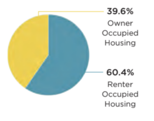
In addition to the older housing stock, the West Ward has a disproportionately high population density and poverty rate compared to the rest of the city. With 1.27 square miles and approximately 9,794 residents, the West Ward houses approximately 36% of Easton’s population. Median household income is $46,835 for Easton as a whole, but only $35,025 in the West Ward. 60% of housing units are renter-occupied, and 58% of households spend 30% or more of their income on rent which qualifies them as ‘cost-burdened’ by the U.S. Department of Housing and Urban Development. Put together, 25.8% of West Ward residents live below the poverty line compared to 18.6% of the city as a whole (West Ward Choice Neighborhood Draft Plan, 2022).
The social and physical qualities of the West Ward make residents more vulnerable to climate change’s effects, such as extreme heat events or flooding. This is because vulnerable groups such as the elderly, children, people with disabilities, people living alone, and people living in poverty are less equipped to respond to hazards effectively. In the realm of energy usage, climate change increases both the frequency and intensity of extreme heat events. In turn, this greatly increases the demand for energy to cool buildings and makes it more likely for the energy grid to be overwhelmed and for blackouts to occur. For some, this would be an inconvenience, but for socially vulnerable groups it can cause significant disruptions to their lives and even injury or death.
The West Ward neighborhood is disproportionately at risk of high energy bills and energy blackouts due to the physical and social vulnerabilities present. As aforementioned, 60.4% of housing units in the West Ward are renter-occupied. Therefore goals surrounding retrofitting homes to increase energy efficiency will be particularly hard to incentivize in this area. This is compounded by the poverty of the neighborhood – a resident could be incentivized to make adjustments but not be able to afford it.
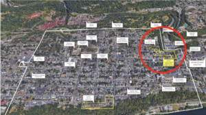
The disparate socioeconomic qualities of the West Ward make it a priority for government support. This priority status is reflected in the West Ward Choice Neighborhoods Draft Plan, published in June 2022. This plan was the result of a $450,000 grant from the Housing and Urban Development (HUD) agency of the federal government and is a comprehensive plan for neighborhood transformation. The grant went into a thorough community engagement process which has resulted in the core goals of People, Neighborhood, and Housing. Most relevant to this report is the Housing section, which has the objective of creating “high-quality, energy-efficient housing that meets resident needs for affordability and a healthy living environment.” To that end, the plan identifies three locations of severely distressed housing that are priorities for redevelopment – N. Union Street Apartments, Elm Street Apartments, and the Bushkill House. The N. Union Street Apartments and Bushkill House are in very close physical proximity to one another (see image XXX). For this reason, we argue that it should be these two units be connected to a microgrid powered by renewable sources. As they are being demolished and rebuilt, time and money will be going towards creating the infrastructure to reconnect these housing units to power. A more socially, environmentally, and economically efficient choice is to use these resources to connect the new housing units to a renewable energy source through a microgrid.
 .
.